اردا، یوتا
Erda, Utah | |
|---|---|
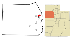
 Location in Tooele County and the state of Utah | |
 Location of Utah in the United States | |
| موختصاتلار: 40°36′26″N 112°18′33″W / 40.60722°N 112.30917°Wموختصات: 40°36′26″N 112°18′33″W / 40.60722°N 112.30917°W | |
| Country | United States |
| State | Utah |
| County | Tooele |
| اراضی | |
| • جمع | ۲۲٫۵ sq mi (۵۸٫۲ km2) |
| • توپراق | ۲۲٫۵ sq mi (۵۸٫۲ km2) |
| • سو | ۰٫۰ sq mi (۰٫۰ km2) |
| اوجالیق | ۴٬۳۴۴ ft (۱٬۳۲۴ m) |
| جمعیت (2010) | |
| • جمع | ۴٬۶۴۲ |
| • سیخلیق | ۲۱۰/sq mi (۸۰/km2) |
| ساعات قورشاغی | یوتیسی -7 (Mountain (MST)) |
| • یای (DST) | یوتیسی -6 (MDT) |
| ZIP code | 84074 |
| تیلفون کودلاری | 435 |
| FIPS code | 49-23640[۱] |
| GNIS feature ID | 1437555[۲] |
- ^ American FactFinder. United States Census Bureau. آرشیولنیب اصلی نۆسخهدن on 2013-09-11. یوْخلانیلیب2008-01-31.
- ^ US Board on Geographic Names. United States Geological Survey (2007-10-25). یوْخلانیلیب2008-01-31.
