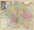
فایل:1740 Homann Map of the Holy Roman Empire ( Germanic Empire ) - Geographicus - ImperiiRomanoGerman-homann-1740.jpg

فایلین اصلی(۵٬۰۰۰ × ۴٬۳۵۳ پیکسل, فایل اؤلچوسو: ۹٫۰۴ مگابایت, MIME نوعو: image/jpeg)

بو فایل ویکی‌انبار-دن‌دیر و آیری پروژه‌ده ایستیفاده اولماق امکانی وار. اونون باره‌سینده اولان شرح فایلین شرح صحیفه‌سی آشاغیدا گوستریلیب.

یوهان هومن: Imperii Romano-Germanici in suos Status et Circulos Divisi Tabula Generalis in Ustus Iuventutis Erudiendae…   (Wikidata search (Cirrus search) Wikidata query (SPARQL)  Create new Wikidata item based on this file)
آرتیست
یوهان هومن  (1664–1724)  wikidata:Q62706
 
یوهان هومن
آیری آدلار
Johann Baptist Homann; Ioannis Baptista Homann; Johann-Baptista Homann; Johann Baptista Homann
آچیقلاما نقشه‌کش، ناشر و copperplate engraver آلمانی
دوغوم/اؤلوم تاریخی ‏۲۰ مارس ۱۶۶۴‏ ویرایش در ویکی‌داده ‏۱ جولای ۱۷۲۴‏ ویرایش در ویکی‌داده
دوغوم/اؤلوم یئری کاملاخ نورنبرق
یارادیجی‌لیق مکانی
کنترل از طریق مرجع
artist QS:P170,Q62706
باشلیق
Imperii Romano-Germanici in suos Status et Circulos Divisi Tabula Generalis in Ustus Iuventutis Erudiendae…
آچیقلاما
English: A beautifully detailed c. 1740 J. B. Homann map of those parts of Europe dominated by the Holy Roman Empire or the German Empire. Depicts most of central Europe from the Netherlands eastward as far as Poland and Hungary and as far south as northern Italy and the Gulf of Venice. Elaborate title cartouche in the upper left quadrant features the Emperor surrounded by angels and heraldic symbols. Map scales in upper right hand quadrant. Key to color coding outside border on lower margin. Alternative title in French in top margin, L’ Allemagne, distinguee en ses Cercles & subdivisee en ses Etats, contenant ... los Elements de Geographiae de Mr. Shatz. This map was drawn in Nuremberg by J. B. Homann and included in the 1752 Homann Heirs Maior Atlas Scholasticus ex Triginta Sex Generalibus et Specialibus…. .
تاریخ حوالی 1720s or 1730s or 1740s(undated)
اؤلچولر بلندی: ۱۸٫۷ اینچ (۴۷٫۶ سانتی‌متر)؛ عرض: ۲۱٫۰ اینچ (۵۳٫۳ سانتی‌متر)
dimensions QS:P2048,18.75U218593
dimensions QS:P2049,21U218593
آی‌دی
منبع/عکاس

Major Atlas Scholasticus Ex Triginta sex Generalibus et Specialibus Mappis Homannianis..., c. 1730. / Also issued in Homann's Grosser Atlas

ایجازه
(فایلین تکرار ایستیفاده‌سی)
این اثر هنری دوبعدی که در این نگاره دیده می‌شود بخاطر تاریخ درگذشت پدیدآورنده آن یا تاریخ انتشارش هم‌اکنون در سراسر جهان در مالکیت عمومی قرار دارد و استفاده از آن آزاد است.
Public domain

این اثر در کشورهایی و مناطقی که مدت زمان حق تکثیر، عمر پدیدآورنده بعلاوه 100 سال یا کمتر بعد از مرگ او است، در مالکیت عمومی قرار دارد.


You must also include a United States public domain tag to indicate why this work is in the public domain in the United States.
بنابراین تکثیر آن در ایالات متحده آمریکا، آلمان و بسیاری کشورهای دیگر آزاد است.

عنوان

شرحی یک‌خطی از محتوای این فایل اضافه کنید

آیتم‌هایی که در این پرونده نمایش داده شده‌اند

توصیف‌ها فارسی

مجموعه فارسی

checksum انگلیسی

ef330026947edd085abda31d87b6d9591787aea7

۹٬۴۸۱٬۸۲۵ بیت

بلندی فارسی

۴٬۳۵۳ پیکسل

عرض فارسی

۵٬۰۰۰ پیکسل

فايل گئچمیشی

فايلین اول‌کی وئرسیياسینی گؤرمک اۆچون گۆن/تاریخ بؤلمه‌سینده‌کی تاریخلری تێقلايین.

تاریخ/واختکیچیک عکساؤلچولرایشلدنباخیش
ایندیکی‏۱۶ مارس ۲۰۱۱، ساعت ۲۱:۱۳‏۱۶ مارس ۲۰۱۱، ساعت ۲۱:۱۳ تاریخینده‌کی سۆروموندن کیچیک گؤرونتوسو۵٬۰۰۰ در ۴٬۳۵۳ (۹٫۰۴ مگابایت)BotMultichill{{subst:User:Multichill/Geographicus |link=http://www.geographicus.com/P/AntiqueMap/ImperiiRomanoGerman-homann-1740 |product_name=1740 Homann Map of the Holy Roman Empire ( Germanic Empire ) |map_title=Imperii Romano-Germanici in suos Status et Circulos D

آشاغیداکی صحیفه بو فایلا باغلانیر

فایلین باشاباش ایشلنیلمه‌سی

بو فایل آشاغی داکی آیری ویکی لرده ایشلَنیر: