فایل:Bristol map 1946.jpg
سیناق گؤستریشی اؤلچوسو: ۶۴۵ × ۵۹۹ پیکسل. آیری کیفیتلر: ۲۵۸ × ۲۴۰ پیکسل | ۵۱۷ × ۴۸۰ پیکسل | ۸۲۷ × ۷۶۸ پیکسل | ۱٬۱۰۲ × ۱٬۰۲۴ پیکسل | ۲٬۲۰۴ × ۲٬۰۴۸ پیکسل | ۴٬۹۶۰ × ۴٬۶۰۸ پیکسل.
فایلین اصلی (۴٬۹۶۰ × ۴٬۶۰۸ پیکسل, فایل اؤلچوسو: ۳٫۷۵ مگابایت, MIME نوعو: image/jpeg)
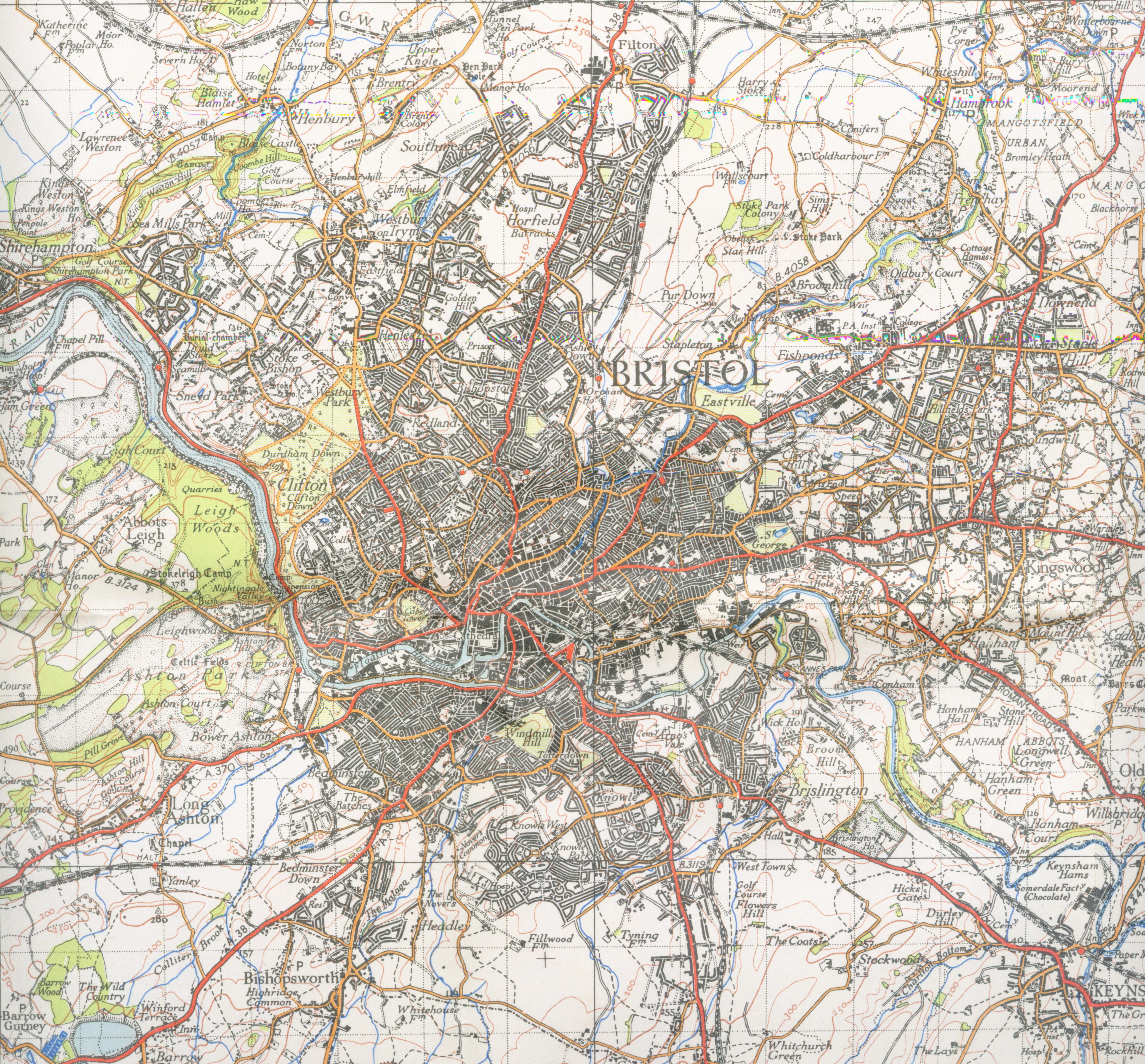
| آچیقلاما | Map of Bristol from 1946. Scale 1 inch to the mile 600DPI Sheet 156 | ||||
| تاریخ | |||||
| قایناق | OS | ||||
| یازار | OS | ||||
| ایجازه (فایلین تکرار ایستیفادهسی) |
|

| مختصات دوربین | | محل قرارگیری این نگاره و سایر نگارهها در: نقشهٔ شهری باز |
|---|
فايل گئچمیشی
فايلین اولکی وئرسیياسینی گؤرمک اۆچون گۆن/تاریخ بؤلمهسیندهکی تاریخلری تێقلايین.
| تاریخ/واخت | کیچیک عکس | اؤلچولر | ایشلدن | باخیش | |
|---|---|---|---|---|---|
| ایندیکی | ۱ دسامبر ۲۰۰۷، ساعت ۲۲:۱۰ | | ۴٬۹۶۰ در ۴٬۶۰۸ (۳٫۷۵ مگابایت) | Geni | trying again |
| ۱۶ سپتامبر ۲۰۰۷، ساعت ۱۷:۲۰ |  | ۴٬۳۵۲ در ۴٬۸۰۰ (۳٫۳۹ مگابایت) | Geni | {{Information |Description=Map of Bristol from 1946. Scale 1 inch to the mile 600DPI Sheet 156 |Source=OS |Date=1946 |Author=OS |Permission=none needed |other_versions= }} {{oldOS}} Category:Maps of cities in the United Kingdom Category:Bristol |
فايل ایشلدمهسی
آشاغیداکی صحیفه بو فایلا باغلانیر
فایلین باشاباش ایشلنیلمهسی
بو فایل آشاغی داکی آیری ویکی لرده ایشلَنیر:
- en.wikipedia.org-ده ایشلنمهسی
- he.wikipedia.org-ده ایشلنمهسی
- kn.wikipedia.org-ده ایشلنمهسی