فایل:Concord Expedition and Patriot Messengers.jpg

سیناق گؤستریشی اؤلچوسو: ۸۰۰ × ۳۴۱ پیکسل. آیری کیفیتلر: ۳۲۰ × ۱۳۶ پیکسل | ۱٬۰۰۰ × ۴۲۶ پیکسل.
فایلین اصلی (۱٬۰۰۰ × ۴۲۶ پیکسل, فایل اؤلچوسو: ۱۳۹ کیلوبایت, MIME نوعو: image/jpeg)

|
این پرونده توسط File:Concord Expedition and Patriot Messengers-en.svg جایگزین شدهاست. توصیه میشود که پروندهٔ دیگر را استفاده کنید. توجه داشته باشید که پاک کردن نگارههای جایگرین شده به رضایت نیاز دارد.
|

|
File:Concord Expedition and Patriot Messengers-en.svg یک نسخهٔ برداری از این پرونده است.
آن پرونده را هنگامی که بهتر بود میبایست به جای این نسخهٔ تصویر استفاده کرد. File:Concord Expedition and Patriot Messengers.jpg → File:Concord Expedition and Patriot Messengers-en.svg
برای کسب اطلاعات بیشتر در ارتباط با تصاویر برداری لطفاً اینجا را مطالعهکنید. همچنین اطلاعات بیشتری در ارتباط با حمایت مدیاویکی از تصاویر اسویجی وجود دارد. |
 |
قیساسی
| عنوان مقاله |
انگلیسی:
Routes of the British Expedition and the Patriot Messengers |
||||||||||||||||||||
| Description |
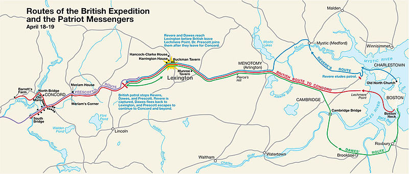
Paul Revere's Midnight Ride English: This is a map depiction the outbound routes taken by Patriot riders and British troops in the Battles of Lexington and Concord on April 19, 1775. |
||||||||||||||||||||
| Map legend |
British route to Concord Revere's route Dawes' route Prescott's route |
||||||||||||||||||||
| تاریخ | تانینمامیش تاریخ; source PDF was created in 2000 | ||||||||||||||||||||
| قایناق | MIMAmap2.pdf ۱۰ مئی ۲۰۰۵ (تاریخ بارگذاری) توسط w:Flying Jazz (دانیشیق | چالیشمالار) | ||||||||||||||||||||
| پدیدآورنده |
نامعلوم for National Park Service |
||||||||||||||||||||
| Geotemporal data | |||||||||||||||||||||
| Date depicted | |||||||||||||||||||||
| Map location | بوستون, ماساچوست ایالتی | ||||||||||||||||||||
| Map type | thematic map | ||||||||||||||||||||
| Heading |
 |
||||||||||||||||||||
| Georeferencing | If inappropriate please set warp_status = skip to hide. | ||||||||||||||||||||
| Bibliographic data | |||||||||||||||||||||
| یایمچی |
National Park Service |
||||||||||||||||||||
| Archival data | |||||||||||||||||||||
| مجموعه |
|
||||||||||||||||||||
| شرح |
باشلیق بالا چپ: Routes of the British Expedition and the Patriot Messengers
متن وسط:
Revere and Dawes reach Lexington before British leave Lechmere Point. Dr. Prescott joins them after they leave for Concord.
متن وسط:
British patrol stops Revere, Dawes, and Prescott. Revere is captured, Dawes flees back to Lexington, and Prescott escapes to continue to Concord and beyond.
|
||||||||||||||||||||
| آیری نوسخهلر |
|
||||||||||||||||||||


لیسانس
| This image or media file contains material based on a work of a National Park Service employee, created as part of that person's official duties. As a work of the U.S. federal government, such work is in the public domain in the United States. See the NPS website and NPS copyright policy for more information. |
اورجینال یوکلمه گوندهلیگی
Transferred from en.wikipedia to Commons by Andrei Stroe using CommonsHelper.
The original description page was here. All following user names refer to en.wikipedia.
- 2005-05-10 09:58 Flying Jazz 1000×426× (141988 bytes) Routes of the British Expedition and the Patriot Messengers April 18-19 (1775) Minute Man National Historical Park Battle Map http://data2.itc.nps.gov/parks/mima/ppMaps/MIMAmap2.pdf {{PD-USGov-Interior-NPS}}
- 2005-05-10 09:54 Flying Jazz 1000×426× (141988 bytes) Minute Man National Historical Park Battle Map http://data2.itc.nps.gov/parks/mima/ppMaps/MIMAmap2.pdf {{PD-USGov-Interior-NPS}}
فايل گئچمیشی
فايلین اولکی وئرسیياسینی گؤرمک اۆچون گۆن/تاریخ بؤلمهسیندهکی تاریخلری تێقلايین.
| تاریخ/واخت | کیچیک عکس | اؤلچولر | ایشلدن | باخیش | |
|---|---|---|---|---|---|
| ایندیکی | ۲۲ نوْوامبر ۲۰۱۰، ساعت ۲۰:۵۰ | | ۱٬۰۰۰ در ۴۲۶ (۱۳۹ کیلوبایت) | File Upload Bot (Magnus Manske) | {{BotMoveToCommons|en.wikipedia|year={{subst:CURRENTYEAR}}|month={{subst:CURRENTMONTHNAME}}|day={{subst:CURRENTDAY}}}} {{Information |Description={{en|This is a map depiction the outbound routes taken by Patriot ride |
فايل ایشلدمهسی
آشاغیداکی صحیفه بو فایلا باغلانیر
فایلین باشاباش ایشلنیلمهسی
بو فایل آشاغی داکی آیری ویکی لرده ایشلَنیر:
- cs.wikipedia.org-ده ایشلنمهسی
- en.wikipedia.org-ده ایشلنمهسی
- fr.wikipedia.org-ده ایشلنمهسی
- it.wikipedia.org-ده ایشلنمهسی
- ro.wikipedia.org-ده ایشلنمهسی
- ru.wikipedia.org-ده ایشلنمهسی
- th.wikipedia.org-ده ایشلنمهسی
- zh.wikipedia.org-ده ایشلنمهسی