فایل:Concord Retreat.png
سیناق گؤستریشی اؤلچوسو: ۸۰۰ × ۳۴۲ پیکسل. آیری کیفیتلر: ۳۲۰ × ۱۳۷ پیکسل | ۶۴۰ × ۲۷۳ پیکسل | ۱٬۰۲۴ × ۴۳۷ پیکسل | ۱٬۲۸۰ × ۵۴۶ پیکسل | ۳٬۲۳۵ × ۱٬۳۸۱ پیکسل.
فایلین اصلی (۳٬۲۳۵ × ۱٬۳۸۱ پیکسل, فایل اؤلچوسو: ۷۸۰ کیلوبایت, MIME نوعو: image/png)
قیساسی
| آچیقلاما |
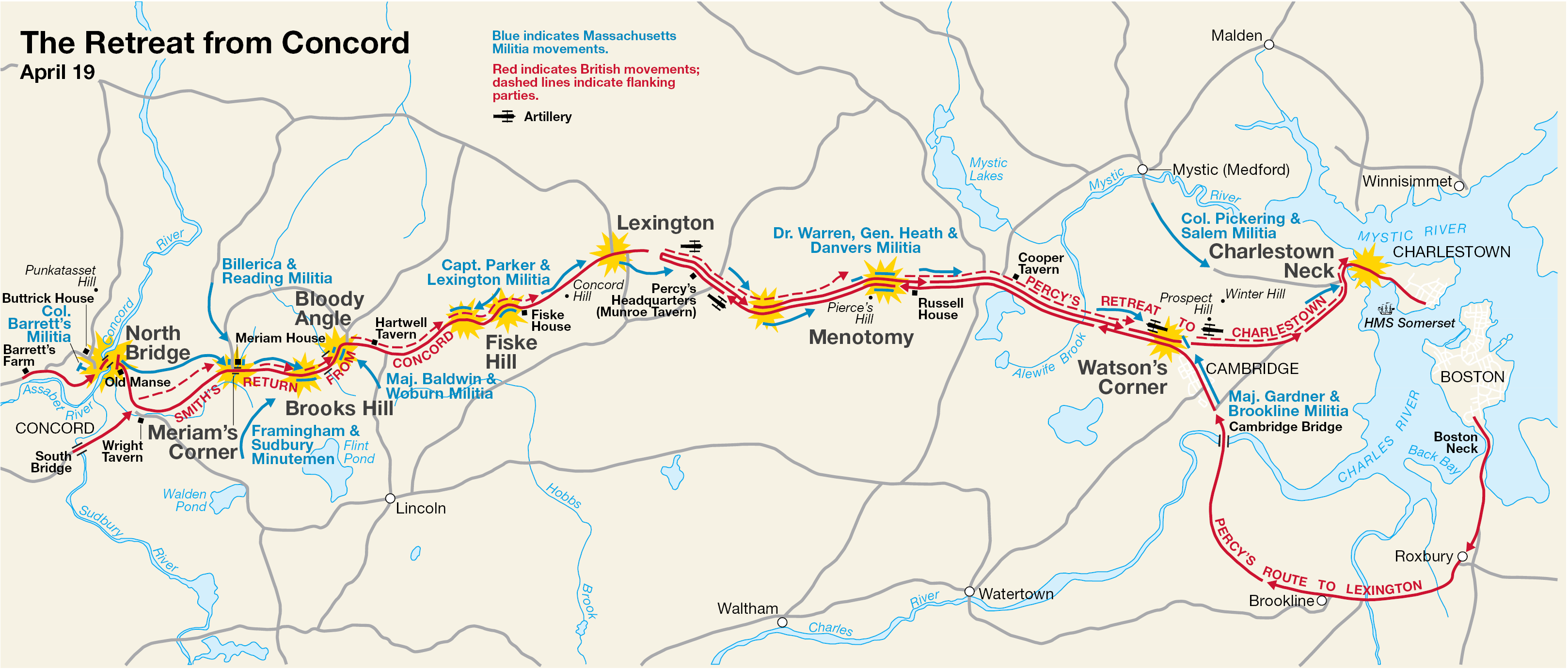
English: This is a map showing the route of the British army's 18-mile retreat from Concord to Charlestown in the Battles of Lexington and Concord on April 19, 1775. It shows the major points of conflict, as well as showing the route taken by Hugh, Earl Percy's reinforcements. |
| تاریخ | تانینمامیش تاریخ; source PDF created in 2000 |
| قایناق | http://data2.itc.nps.gov/parks/mima/ppMaps/MIMAmap2.pdf |
| یازار | National Park Service |
| آیری نوسخهلر |
|

لیسانس
| This image or media file contains material based on a work of a National Park Service employee, created as part of that person's official duties. As a work of the U.S. federal government, such work is in the public domain in the United States. See the NPS website and NPS copyright policy for more information. |
اورجینال یوکلمه گوندهلیگی
Transferred from en.wikipedia to Commons by Andrei Stroe using CommonsHelper.
صفحهٔ اصلی توضیحات اینجابود. همهٔ نامهای کاربر زیر به en.wikipedia اشاره دارند.
- 2006-11-30 17:35 Irayo 3235×1381× (799048 bytes) The Retreat from Concord April 19 (1775) Minute Man National Historical Park Battle Map http://data2.itc.nps.gov/parks/mima/ppMaps/MIMAmap2.pdf {{PD-USGov-Interior-NPS}}
فايل گئچمیشی
فايلین اولکی وئرسیياسینی گؤرمک اۆچون گۆن/تاریخ بؤلمهسیندهکی تاریخلری تێقلايین.
| تاریخ/واخت | کیچیک عکس | اؤلچولر | ایشلدن | باخیش | |
|---|---|---|---|---|---|
| ایندیکی | ۲۹ نوْوامبر ۲۰۱۰، ساعت ۱۹:۱۱ | | ۳٬۲۳۵ در ۱٬۳۸۱ (۷۸۰ کیلوبایت) | File Upload Bot (Magnus Manske) | {{BotMoveToCommons|en.wikipedia|year={{subst:CURRENTYEAR}}|month={{subst:CURRENTMONTHNAME}}|day={{subst:CURRENTDAY}}}} {{Information |Description={{en|This is a map showing the route of the British army's 18-mile retreat from [[:en:Concord, Massachusetts |
فايل ایشلدمهسی
آشاغیداکی صحیفه بو فایلا باغلانیر
فایلین باشاباش ایشلنیلمهسی
بو فایل آشاغی داکی آیری ویکی لرده ایشلَنیر:
- ar.wikipedia.org-ده ایشلنمهسی
- cs.wikipedia.org-ده ایشلنمهسی
- en.wikipedia.org-ده ایشلنمهسی
- es.wikipedia.org-ده ایشلنمهسی
- fr.wikipedia.org-ده ایشلنمهسی
- it.wikipedia.org-ده ایشلنمهسی
- ro.wikipedia.org-ده ایشلنمهسی
- ru.wikipedia.org-ده ایشلنمهسی
- th.wikipedia.org-ده ایشلنمهسی
- zh.wikipedia.org-ده ایشلنمهسی