فایل:East Francia 843.svg

حجم پیشنمایش PNG این SVG file:۵۰۰ × ۳۸۰ پیکسل آیری کیفیتلر: ۳۱۶ × ۲۴۰ پیکسل | ۶۳۲ × ۴۸۰ پیکسل | ۱٬۰۱۱ × ۷۶۸ پیکسل | ۱٬۲۸۰ × ۹۷۳ پیکسل | ۲٬۵۶۰ × ۱٬۹۴۶ پیکسل.
فایلین اصلی (SVG فایلی، ۵۰۰ × ۳۸۰ پیکسئل، فایلین اؤلچوسو: ۹۳۳ کیلوبایت)
قیساسی


.svg)
.svg)
.svg)
.svg)
.svg)


.svg)
.svg)
.svg)


.png)
.png)


.svg)


.svg)

.svg)


.svg)
.svg)
.svg)
.svg)


.svg)
.png)


.svg)


.svg)
.svg)


.svg)


.svg)


.svg)
.svg)
.svg)
.svg)
.svg)
.svg)
.svg)
_cropped.svg)
.svg)
.svg)
.svg)
.svg)
.svg)
.svg)
.svg)
.svg)
.svg)
.svg)
.svg)
.svg)
.svg)
.svg)
.svg)
.svg)
.svg)
.svg)
.svg)
.svg)
.svg)
.svg)
.svg)
.svg)
.svg)
.svg)
.svg)
.svg)
.svg)
.svg)
.svg)
.svg)
.svg)
.svg)
.svg)
.svg)
.svg)
.svg)
.svg)
.svg)
.svg)
.svg)
.svg)
.svg)
.svg)
لیسانس
این پرونده تحت پروانهٔ Creative Commons Attribution-Share Alike 4.0 International منتشر شده است.
- سیزین ایجازه نیز وار دیر:
- بؤلۆشمک – اثرین کپی، پایلاشماق و چاتدیرماسی اوچون
- تلفیق ائت – اثرین توتوشدورماسی اوچون
- آشاغی داکی شرایطله:
- تخصیص – اثری مؤلف و یا لیسئنزییالی طرفیندن گؤستریلدیی کیمی ایستیناد ائتملیسینیز (آنجاق سنی دستکلدیینی و یا اثردن ایستیفاده ائتمیینیزی تکلیف ائتمملیسینیز).
- بیرگه پایلاشیم – اگر بو اثرده دَییشدیرمه، چؤندرمه، یا دا کؤکدن دوزلتمه ائتسز، اله گلمیش اثری یالنیز بیر ائشیت یوخسا اوخشار بیر مجوزین آلتیندا یاییملایابیلرسینیز .
فايل گئچمیشی
فايلین اولکی وئرسیياسینی گؤرمک اۆچون گۆن/تاریخ بؤلمهسیندهکی تاریخلری تێقلايین.
| تاریخ/واخت | کیچیک عکس | اؤلچولر | ایشلدن | باخیش | |
|---|---|---|---|---|---|
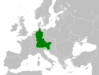
| ایندیکی | ۶ آقوست ۲۰۲۱، ساعت ۱۰:۰۶ | | ۵۰۰ در ۳۸۰ (۹۳۳ کیلوبایت) | E-960 | Vassal states (aka Slavic tribes) did not make up the territory of East Francia, also in most cases it only represented an alliance with East Francia rather than subjugation. |
| ۲۶ مئی ۲۰۱۶، ساعت ۰۲:۲۵ |  | ۵۰۰ در ۳۸۰ (۹۳۲ کیلوبایت) | Alphathon | == {{int:filedesc}} == {{Inkscape}} {{Information |Description={{en|A map of East Francia within Europe circa 843 CE, following the treaty of Verdun.}} |Source= {{Derived from|Blank_map_of_Europe.svg|display=50}} '''Data sour... |
فايل ایشلدمهسی
آشاغیداکی صحیفه بو فایلا باغلانیر
فایلین باشاباش ایشلنیلمهسی
بو فایل آشاغی داکی آیری ویکی لرده ایشلَنیر:
- bg.wikipedia.org-ده ایشلنمهسی
- ceb.wikipedia.org-ده ایشلنمهسی
- cs.wikipedia.org-ده ایشلنمهسی
- da.wikipedia.org-ده ایشلنمهسی
- el.wikipedia.org-ده ایشلنمهسی
- en.wikipedia.org-ده ایشلنمهسی
- es.wikipedia.org-ده ایشلنمهسی
- et.wikipedia.org-ده ایشلنمهسی
- fa.wikipedia.org-ده ایشلنمهسی
- fi.wikipedia.org-ده ایشلنمهسی
- fr.wikipedia.org-ده ایشلنمهسی
- fy.wikipedia.org-ده ایشلنمهسی
- he.wikipedia.org-ده ایشلنمهسی
- hr.wikipedia.org-ده ایشلنمهسی
- hy.wikipedia.org-ده ایشلنمهسی
- id.wikipedia.org-ده ایشلنمهسی
- it.wikipedia.org-ده ایشلنمهسی
- ja.wikipedia.org-ده ایشلنمهسی
- ko.wikipedia.org-ده ایشلنمهسی
- ku.wikipedia.org-ده ایشلنمهسی
- la.wikipedia.org-ده ایشلنمهسی
- lv.wikipedia.org-ده ایشلنمهسی
- mk.wikipedia.org-ده ایشلنمهسی
- pl.wikipedia.org-ده ایشلنمهسی
- pt.wikipedia.org-ده ایشلنمهسی
- ru.wikipedia.org-ده ایشلنمهسی
- sl.wikipedia.org-ده ایشلنمهسی
- sr.wikipedia.org-ده ایشلنمهسی
- th.wikipedia.org-ده ایشلنمهسی
- tr.wikipedia.org-ده ایشلنمهسی
- uk.wikipedia.org-ده ایشلنمهسی
- vi.wikipedia.org-ده ایشلنمهسی
- zh.wikipedia.org-ده ایشلنمهسی
بو فایلینسراسری ایستفاده لرینه باخین.