فایلین اصلی(۱٬۹۲۰ × ۱٬۴۴۰ پیکسل, فایل اؤلچوسو: ۱٫۴۱ مگابایت, MIME نوعو: image/jpeg)

بو فایل ویکی‌انبار-دن‌دیر و آیری پروژه‌ده ایستیفاده اولماق امکانی وار. اونون باره‌سینده اولان شرح فایلین شرح صحیفه‌سی آشاغیدا گوستریلیب.

قیساسی

آچیقلاما
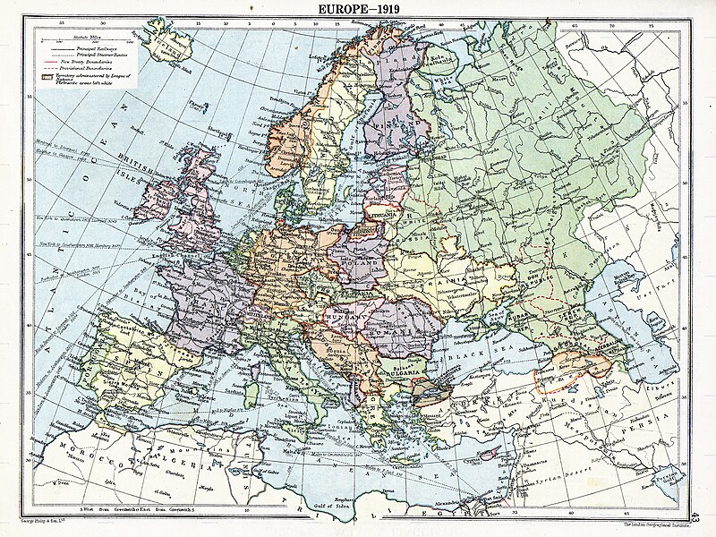
English: Map of en:Europe political divisions in 1919 (after the treaties of Brest-Litovsk and Versailles and before the treaties of Trianon, Riga, Kars and the establishment of en:Soviet Union and the republics of Ireland and Turkey) published by London Geographical Institute. This uploaded map is a photoshopped version of the original image located at hipkiss.org. According to the site, there are no copyrights to this map.
قایناق
یازار
آیری نوسخه‌لر آثار انشقاقی از این پرونده:  Europe map 1919 cropped.JPG
Maps of the history of Europe
BCE
aC

Weichselian ice age (c. 113,000–9700) · Neolithic expansion (c. 7000–4500) · Middle Neolithic (c. 4500–4000) · Late Neolithic (c. 4000–3000) · Copper Age – Corded Ware culture (c. 2900–2350) · Copper Age – Bellbeaker culture (c. 2800–1800) · Early Bronze Age – Unetice culture (c. 2300–1600) · Late Bronze Age – Urnfield culture (c. 1300—750) · Migrations (c. 1000–100) · Hallstatt & La Tène cultures (c. 800–100) · Roman Republic (510–40) · 220 · 218 · 200 · 201–100 · 58 · 49 · 39 · 30 BCE–6 CE


CE
dC

14 · 14–37 · 60 · 60 · 69 · 80 · Migrations 100–500 · 117 · 117 · 125 · Migrations 150–774 · Economy 180 · 271 · 293–305 · 337 · 395 · c. 395 · 400 · 400 · 450 · 457–61 · 476 · 480 · Franks 481–814 · Early Slavs 500–700 · 500 · 526 · 526–600 · Christianisation to 600 · c. 550 · 650 · Pontic Steppe 650 · 665 · 800 · Vikings 800–1050 · 814 · 843–70 · 850 · 900 · 912 · 998 · 1000 · 1000 · 1054 · 1092 · First Crusade 1095–99 · 1097 · 1135 · 1142 · 1147–49 · 1190 · 1190 · 1250 · c. 1250 · 1301-1400 · 1301-1400 · 1328 · 1345 · Black Plague 1347–51 · 1360 · 1400 · Trade routes c. 1400 · 1430 · 1470 · 1490 · 1492 · 1500 · 1519 · 1550 · 1560 · Religion 1560 · Religion 1600 · Religion 1618 · 1618–48 · 1648 · 1683 · 1700 · 1701 · 1708 · 1714 · 1721 · 1725–30 · 1739–1740 · 1740 · 1748–66 · 1783–1792 · 1787 · 1787 · 1789 · 1799 · 1812 · 1812 · 1812 · 1812 · 1813 · 1815 · 1815 · 1815 · 1818 · Ottoman Empire 1830–1923 · 1848–49 · 1861 · 1867 · 1871 · 1878 · 1890 · 1905 · 1911 · 1914 · 1914 · 1919 · 1919–29 · 1923 · 1929 · 1930 · 1940 · 1941–42 · 1942–45 · Cold War 1947–91 · 1950 · 1993–2006 · 2006 to date

(this template: · view · discuss )

لیسانس

Public domain
Public domain
این پروندهٔ رسانه‌ای در ایالات متحده در مالکیت عمومی قرار دارد. این دربارهٔ آثار ایالات متحده که حق‌تکثیرشان باطل شده است صدق می‌کند؛ اغلب به این دلیل که اولین انتشارشان قبل از ۱ ژانویهٔ ۱۹۲۹ روی داده است. برای توضیحات بیش‌تر این صفحه را ببینید.

United States
United States
ممکن است این نگاره در خارج از ایالات متحده در مالکیت عمومی نباشد؛ این مسئله به‌خصوص دربارهٔ کشورها و مناطقی که قانون مدت کوتاه‌تر را برای آثار ایالات متحدهٔ آمریکا اعمال نمی‌کنند، همچون کانادا، چین (به جز هنگ‌کنگ و ماکائو)، آلمان، مکیزیک، و سوئیس صدق می‌کند. آفریننده و سال انتشار اطلاعات ضروری هستند و باید ارائه شوند. برای جزئیات بیش‌تر، ویکی‌پدیا:مالکیت عمومی و ویکی‌پدیا:حق تکثیر را ببینید.

اورجینال یوکلمه گونده‌لیگی

صفحهٔ اصلی توضیحات اینجابود. همهٔ نام‌های کاربر زیر به en.wikipedia اشاره دارند.
  • 2007-11-03 20:09 MaGioZal 1996×1506×8 (1457003 bytes) Map of [[Europe]] political divisions in 1919 (after the treaties of [[Treaty_of_Brest-Litovsk|Brest-Livotsk]] and [[Treaty of Versailles|Versailles]] and before the [[Treaty of Riga]] and the creation of [[Soviet Union]]) published by London Geographical

عنوان

شرحی یک‌خطی از محتوای این فایل اضافه کنید
The situation in Europe after WW1. Several new states were born such as Ukraine(the country in Yellow at the North of the Black Sea)

آیتم‌هایی که در این پرونده نمایش داده شده‌اند

توصیف‌ها فارسی

فايل گئچمیشی

فايلین اول‌کی وئرسیياسینی گؤرمک اۆچون گۆن/تاریخ بؤلمه‌سینده‌کی تاریخلری تێقلايین.

تاریخ/واختکیچیک عکساؤلچولرایشلدنباخیش
ایندیکی‏۷ آقوست ۲۰۲۳، ساعت ۰۵:۴۱‏۷ آقوست ۲۰۲۳، ساعت ۰۵:۴۱ تاریخینده‌کی سۆروموندن کیچیک گؤرونتوسو۱٬۹۲۰ در ۱٬۴۴۰ (۱٫۴۱ مگابایت)User-duckCropped to reduce border using CropTool with lossless mode.
‏۲۲ آوریل ۲۰۰۸، ساعت ۲۳:۲۹‏۲۲ آوریل ۲۰۰۸، ساعت ۲۳:۲۹ تاریخینده‌کی سۆروموندن کیچیک گؤرونتوسو۱٬۹۹۶ در ۱٬۵۰۶ (۱٫۳۹ مگابایت)File Upload Bot (Magnus Manske) {{BotMoveToCommons|en.wikipedia}} {{Information |Description={{en|Map of en:Europe political divisions in 1919 (after the treaties of Brest-Livotsk and Versailles and before the treaties o

فایلین باشاباش ایشلنیلمه‌سی

بو فایل آشاغی داکی آیری ویکی لرده ایشلَنیر:

بو فایلینسراسری ایستفاده لرینه باخین.