فایل:Falkland Islands topographic map-fr.svg

حجم پیشنمایش PNG این SVG file:۷۶۸ × ۵۹۹ پیکسل آیری کیفیتلر: ۳۰۸ × ۲۴۰ پیکسل | ۶۱۵ × ۴۸۰ پیکسل | ۹۸۴ × ۷۶۸ پیکسل | ۱٬۲۸۰ × ۹۹۹ پیکسل | ۲٬۵۶۰ × ۱٬۹۹۸ پیکسل | ۲٬۵۵۰ × ۱٬۹۹۰ پیکسل.
فایلین اصلی (SVG فایلی، ۲٬۵۵۰ × ۱٬۹۹۰ پیکسئل، فایلین اؤلچوسو: ۱٫۹۳ مگابایت)
This SVG map uses required raster graphics to show delicate structures.
![]()
Detailed map of large dimension. For a better viewing, click on the link of the image above.
Carte détaillée de grande dimension. Pour une visualisation optimale, cliquer sur le lien de l'image ci-dessus.
قیساسی
| آچیقلاما |
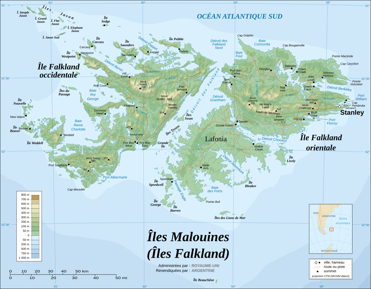
English: Topographic map of the Falkland Islands (in French). The Falkland Islands are an archipelago in the South Atlantic Ocean, located 300 miles off the coast of Argentina. They consist of two main islands, East Falkland and West Falkland, together with about 700 smaller islands. Stanley, on East Falkland, is the capital and largest city. The islands are a self-governing Overseas Territory of the United Kingdom.
Français : Carte topographique des Îles Malouines. Les Malouines forment un archipel dans l'Océan Atlantique Sud à 480 km des côtes argentines. Il est composé de deux îles principales, East Falkland et West Falkland, et de 700 autres îles et îlots. Stanley, sur East Falkland, est la capitale et la plus grande agglomération de l'archipel. Les Malouines sont un territoire autonome du Royaume-Uni. |
||
| تاریخ | November 2007 using elements from the original version of April 2007 | ||
| قایناق |
Own work ; Topographic map : NASA Shuttle Radar Topography Mission (SRTM3 v.2) (public domain) edited with dlgv32 Pro/Global Mapper and vectorized with Inkscape ; UTM projection ; WGS84 datum ; shaded relief (composite image of N-W, W and N lightning positions) ; Approximate scale of topographic data and shore / lakes limits : 1:705,000 ; of the bathymetry : 1:3.720.000 Bathymetry : USGov public domain data provided by the Demis add-on for World Wind (see the approval e-mail) ; Other references used for additional data : * UK government map ; * NASA World Wind ; * CIA map available on the site of the University of Texas at Austin ; * Microsoft Encarta atlas (1999 edition). Note : The shaded relief is a raster image embedded in the SVG file which increases its size. If you want a lighter map for other purposes, delete the shaded relief image in your file. |
||
| یازار | Eric Gaba (Sting - fr:Sting) | ||
| ایجازه (فایلین تکرار ایستیفادهسی) |
|
||
| آیری نوسخهلر |
[]
|


.svg)


.svg)


|
This SVG file contains embedded text that can be translated into your language, using any capable SVG editor, text editor or the SVG Translate tool. For more information see: About translating SVG files. |
لیسانس
من، صاحب حقوق قانونی این اثر، به این وسیله این اثر را تحث اجازهنامههای ذیل منتشر میکنم:

|
اجازهٔ کپی، پخش و/یا تغییر این سند تحت شرایط مجوز مستندات آزاد گنو، نسخهٔ ۱٫۲ یا هر نسخهٔ بعدتری که توسط بنیاد نرمافزار آزاد منتشر شده؛ بدون بخشهای ناوردا (نامتغیر)، متون روی جلد، و متون پشت جلد، اعطا میشود. یک کپی از مجوز در بخشی تحت عنوان مجوز مستندات آزاد گنو ضمیمه شده است.
بو فایلین،
کوپیالانماسی، پایلانماسی و / و یا دییشدیریلمهسینه ایجازه وئریلمیشدیر. لیسئنزیانین بیر کوپیاسی،مجوز مستندات آزاد گنوباشلیقلی حیسهده ایشتیراک ائتمکدهدیر. |
| بو فایل کریتیو کامانز مجوز ایله Attribution-Share Alike 3.0 اویغونلاشمامیش یاییملانیبدیر. | ||
| ||
| این برچسب مجوز بهعنوان بخشی از روزآمدسازی مجوز GFDL، به این پرونده افزوده شد. |
این پرونده با اجازهنامهٔ کریتیو کامانز Attribution-Share Alike 2.5 عمومی، 2.0 عمومی و 1.0 عمومی منتشر شده است.
- سیزین ایجازه نیز وار دیر:
- بؤلۆشمک – اثرین کپی، پایلاشماق و چاتدیرماسی اوچون
- تلفیق ائت – اثرین توتوشدورماسی اوچون
- آشاغی داکی شرایطله:
- تخصیص – اثری مؤلف و یا لیسئنزییالی طرفیندن گؤستریلدیی کیمی ایستیناد ائتملیسینیز (آنجاق سنی دستکلدیینی و یا اثردن ایستیفاده ائتمیینیزی تکلیف ائتمملیسینیز).
- بیرگه پایلاشیم – اگر بو اثرده دَییشدیرمه، چؤندرمه، یا دا کؤکدن دوزلتمه ائتسز، اله گلمیش اثری یالنیز بیر ائشیت یوخسا اوخشار بیر مجوزین آلتیندا یاییملایابیلرسینیز .
ایستدیگینیز لیسئنزیانی سئچه بیلرسینیز.
فايل گئچمیشی
فايلین اولکی وئرسیياسینی گؤرمک اۆچون گۆن/تاریخ بؤلمهسیندهکی تاریخلری تێقلايین.
| تاریخ/واخت | کیچیک عکس | اؤلچولر | ایشلدن | باخیش | |
|---|---|---|---|---|---|
| ایندیکی | ۱۶ نوْوامبر ۲۰۰۷، ساعت ۱۸:۴۹ | | ۲٬۵۵۰ در ۱٬۹۹۰ (۱٫۹۳ مگابایت) | Sting | New background ; some names correction / addition ; - 1982 CIA census data |
| ۵ آوریل ۲۰۰۷، ساعت ۱۹:۱۳ |  | ۲٬۵۵۰ در ۱٬۹۹۰ (۲٫۰۳ مگابایت) | Sting | Enhanced shaded relief | |
| ۵ آوریل ۲۰۰۷، ساعت ۰۵:۰۹ |  | ۲٬۵۵۰ در ۱٬۹۹۰ (۱٫۸۶ مگابایت) | Sting | {{Information |Description={{en}}The '''Falkland Islands''' are an archipelago in the South Atlantic Ocean, located 300 miles off the coast of Argentina. They consist of two main islands, East Falkland and West Falkland, together with about 700 smalle |
فايل ایشلدمهسی
آشاغیداکی صحیفه بو فایلا باغلانیر
فایلین باشاباش ایشلنیلمهسی
بو فایل آشاغی داکی آیری ویکی لرده ایشلَنیر:
- fr.wikipedia.org-ده ایشلنمهسی