فایل:Frankish kingdoms in 628.jpg

فایلین اصلی (۱٬۲۳۹ × ۱٬۱۴۹ پیکسل, فایل اؤلچوسو: ۳۵۵ کیلوبایت, MIME نوعو: image/jpeg)
قیساسی
| آچیقلاما |
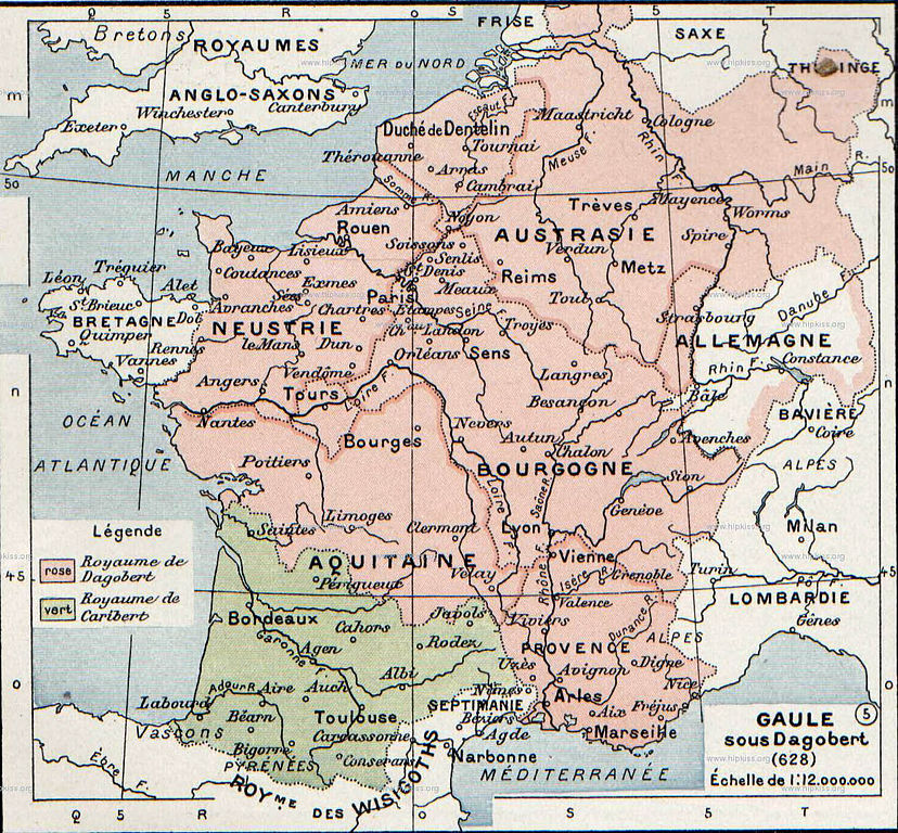
English: The map comes from Vidal-Lablache, Atlas général d'histoire et de géographie (1894). It shows the Frankish kingdoms in 628 AD.
Français : Gaule sous Dagobert (628). Paul Vidal de La Blache, Atlas général d'histoire et de géographie (1894). |
||||||||||||||||||||
| تاریخ | |||||||||||||||||||||
| قایناق | Paul Vidal de La Blache, Atlas général d'histoire et de géographie (1894). | ||||||||||||||||||||
| یازار |
|
||||||||||||||||||||

لیسانس
This image is in the public domain because it is a mere mechanical scan or photocopy of a public domain original, or – from the available evidence – is so similar to such a scan or photocopy that no copyright protection can be expected to arise. The original itself is in the public domain for the following reason:
This tag is designed for use where there may be a need to assert that any enhancements (eg brightness, contrast, colour-matching, sharpening) are in themselves insufficiently creative to generate a new copyright. It can be used where it is unknown whether any enhancements have been made, as well as when the enhancements are clear but insufficient. For known raw unenhanced scans you can use an appropriate {{PD-old}} tag instead. For usage, see Commons:When to use the PD-scan tag.  | ||||
اورجینال یوکلمه گوندهلیگی
- 2007-08-19 21:37 Srnec 1239×1149×8 (363198 bytes) The map comes from Vidal-Lablache, ''Atlas général d'histoire et de géographie'' (1894). {{PD-art-life-70}}
فايل گئچمیشی
فايلین اولکی وئرسیياسینی گؤرمک اۆچون گۆن/تاریخ بؤلمهسیندهکی تاریخلری تێقلايین.
| تاریخ/واخت | کیچیک عکس | اؤلچولر | ایشلدن | باخیش | |
|---|---|---|---|---|---|
| ایندیکی | ۲۶ نوْوامبر ۲۰۰۷، ساعت ۲۰:۱۹ | | ۱٬۲۳۹ در ۱٬۱۴۹ (۳۵۵ کیلوبایت) | Obersachse | {{Information |Description={{en|The map comes from Vidal-Lablache, ''Atlas général d'histoire et de géographie'' (1894).}} |Source=Transfered from [http://en.wikipedia.org en.wikipedia] |Date=2007-08-19 (original upload date) |Author=Original uploader |
فايل ایشلدمهسی
آشاغیداکی صحیفه بو فایلا باغلانیر
فایلین باشاباش ایشلنیلمهسی
بو فایل آشاغی داکی آیری ویکی لرده ایشلَنیر:
- af.wikipedia.org-ده ایشلنمهسی
- als.wikipedia.org-ده ایشلنمهسی
- arz.wikipedia.org-ده ایشلنمهسی
- be.wikipedia.org-ده ایشلنمهسی
- bg.wikipedia.org-ده ایشلنمهسی
- br.wikipedia.org-ده ایشلنمهسی
- ca.wikipedia.org-ده ایشلنمهسی
- de.wikipedia.org-ده ایشلنمهسی
- el.wikipedia.org-ده ایشلنمهسی
- en.wikipedia.org-ده ایشلنمهسی
- eo.wikipedia.org-ده ایشلنمهسی
- es.wikipedia.org-ده ایشلنمهسی
- eu.wikipedia.org-ده ایشلنمهسی
- fr.wikipedia.org-ده ایشلنمهسی
- gl.wikipedia.org-ده ایشلنمهسی
- he.wikipedia.org-ده ایشلنمهسی
- hy.wikipedia.org-ده ایشلنمهسی
- id.wikipedia.org-ده ایشلنمهسی
- it.wikipedia.org-ده ایشلنمهسی
- ko.wikipedia.org-ده ایشلنمهسی
- nl.wikipedia.org-ده ایشلنمهسی
- pt.wikipedia.org-ده ایشلنمهسی
بو فایلینسراسری ایستفاده لرینه باخین.