فایل:HMSO Graf Spee map of River Plate.jpg
یوخاری کیفیت الده یوخدور.
HMSO_Graf_Spee_map_of_River_Plate.jpg (۷۵۱ × ۵۱۷ پیکسل, فایل اؤلچوسو: ۵۷ کیلوبایت, MIME نوعو: image/jpeg)
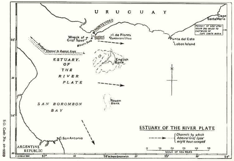
| آچیقلاما | Map of the estuary of the River Plate showing possible exit channels available to the German heavy cruiser Admiral Graf Spee after the Battle of the River Plate in December 1939. | |||
| تاریخ | ||||
| قایناق |
From official British report into the cruise of the Graf Spee and Battle of the River Plate. Published by HMSO (His Majesty's Stationery Office). Originally uploaded to EN Wikipedia as en:File:HMSO Graf Spee map of River Plate.jpg by en:User:Duncharris 26 December 2004; modified by en:User:Lhgodoy 22 March 2006. |
|||
| یازار | British Government | |||
| ایجازه (فایلین تکرار ایستیفادهسی) |
Crown Copyright expired (50 years)
|
|||
| آیری نوسخهلر | en:File:HMSO Graf Spee map of River Plate.jpg |

فايل گئچمیشی
فايلین اولکی وئرسیياسینی گؤرمک اۆچون گۆن/تاریخ بؤلمهسیندهکی تاریخلری تێقلايین.
| تاریخ/واخت | کیچیک عکس | اؤلچولر | ایشلدن | باخیش | |
|---|---|---|---|---|---|
| ایندیکی | ۲۰ دسامبر ۲۰۰۹، ساعت ۱۷:۰۵ | | ۷۵۱ در ۵۱۷ (۵۷ کیلوبایت) | Rcbutcher | {{Information |Description=Map of the estuary of the River Plate showing possible exit channels available to the German heavy cruiser Admiral Graf Spee after the Battle of the River Plate in December 1939. |Source=From official British report into the cru |
فايل ایشلدمهسی
آشاغیداکی صحیفه بو فایلا باغلانیر
فایلین باشاباش ایشلنیلمهسی
بو فایل آشاغی داکی آیری ویکی لرده ایشلَنیر:
- ca.wikipedia.org-ده ایشلنمهسی
- de.wikipedia.org-ده ایشلنمهسی
- en.wikipedia.org-ده ایشلنمهسی
- es.wikipedia.org-ده ایشلنمهسی
- hu.wikipedia.org-ده ایشلنمهسی
- it.wikipedia.org-ده ایشلنمهسی
- nl.wikipedia.org-ده ایشلنمهسی