فایلین اصلی(۳٬۶۰۰ × ۲٬۸۰۰ پیکسل, فایل اؤلچوسو: ۱٫۱۶ مگابایت, MIME نوعو: image/jpeg)

بو فایل ویکی‌انبار-دن‌دیر و آیری پروژه‌ده ایستیفاده اولماق امکانی وار. اونون باره‌سینده اولان شرح فایلین شرح صحیفه‌سی آشاغیدا گوستریلیب.

قیساسی

آچیقلاما
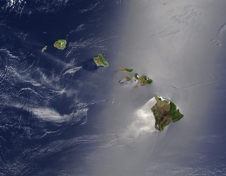
English: Satellite view of Hawaii archipellago (USA).

Original description from NASA:

"A silver swath of sunglint surrounds half of the Hawaiian islands in this true-color Terra MODIS image acquired on May 27, 2003. Sunglint reveals turbulence in the surface waters of the Pacific Ocean. If the surface of the water was as smooth as a perfect mirror, we would see the circle of the Sun as a perfect reflection. But because the surface of the water is ruffled with waves, each wave acts like a mirror and the Sun’s reflection gets softened into a broader silver swath, called the sunglint region.

"In this scene, the winds ruffling the water surface around the Hawaiian Islands create varying patterns, leaving some areas calmer than others. Southwest of Hawaii and Maui, on their leeward sides, calmer waters are indicated by brighter silver coloration. Conversely, notice how most of the vegetation on the Hawaiian Islands grows on their northeastern, or windward, sides.

"From lower right to upper left, the “Big Island” (Hawaii), Maui, Kahoolawe, Lanai, Molokai, Oahu, Kauai, and Niihau islands all make up the state of Hawaii, which lies more than 2,000 miles from any other part of the United States. The small red dot on the Big Island’s southeastern side marks a hot spot on Kilauea Volcano’s southern flank. Kilauea has been erupting almost continuously since January 1983, and is one of the world’s best studied volcanoes."
Français : Vue satellite de l'archipel d'Hawaï (États-Unis).
تاریخ
قایناق NASA. Image courtesy Jacques Descloitres, MODIS Land Rapid Response Team at NASA GSFC. (IotD Date: 2003-06-03. IotD ID: 15304)
یازار Jacques Descloitres
آیری نوسخه‌لر
Modified version
این یک عکس دستکاری شده است به این معنی که به صورت دیجیتالی از نسخهٔ اصلی تغییر یافته‌است. تغییرها: cloned out and healed little red line on the big island. اصل آن را می‌توان در اینجا مشاهده کرد: Hawaje.jpg. تغییرها توسط IdLoveOne انجام شده‌است.

Derivative works

Derivative works of this file:  Hawaje-NoRedLine.jpg

لیسانس

Public domain این پرونده در مالکیت عمومی قرار دارد چرا که توسط ناسا ایجاد شده است. سیاست حق تکثیر ناسا بیان می‌کند که «مواد ناسا با حق تکثیر محافظت نمی‌شوند، مگراینکه ذکر شده باشد». (Template:PD-USGov، صفحهٔ سیاست حق تکثیر ناسا یا سیاست جی‌پی‌ال استفاده از تصاویر را ببینید.)
هشدارها:

عنوان

شرحی یک‌خطی از محتوای این فایل اضافه کنید

آیتم‌هایی که در این پرونده نمایش داده شده‌اند

توصیف‌ها فارسی

۲۷ مئی 2003

فايل گئچمیشی

فايلین اول‌کی وئرسیياسینی گؤرمک اۆچون گۆن/تاریخ بؤلمه‌سینده‌کی تاریخلری تێقلايین.

تاریخ/واختکیچیک عکساؤلچولرایشلدنباخیش
ایندیکی‏۲۶ اوْکتوبر ۲۰۰۵، ساعت ۱۸:۱۹‏۲۶ اوْکتوبر ۲۰۰۵، ساعت ۱۸:۱۹ تاریخینده‌کی سۆروموندن کیچیک گؤرونتوسو۳٬۶۰۰ در ۲٬۸۰۰ (۱٫۱۶ مگابایت)PalladinusHawaii Islands

بو فایلا هئچ بیر صفحه‌یه باغلانماییب.

فایلین باشاباش ایشلنیلمه‌سی

بو فایل آشاغی داکی آیری ویکی لرده ایشلَنیر:

مِتابیلگی‌لر