فایل:Hokushin-ron-Map.svg

حجم پیشنمایش PNG این SVG file:۸۰۰ × ۵۱۲ پیکسل آیری کیفیتلر: ۳۲۰ × ۲۰۵ پیکسل | ۶۴۰ × ۴۰۹ پیکسل | ۱٬۰۲۴ × ۶۵۵ پیکسل | ۱٬۲۸۰ × ۸۱۹ پیکسل | ۲٬۵۶۰ × ۱٬۶۳۸ پیکسل | ۱٬۰۳۸ × ۶۶۴ پیکسل.
فایلین اصلی (SVG فایلی، ۱٬۰۳۸ × ۶۶۴ پیکسئل، فایلین اؤلچوسو: ۶۴۹ کیلوبایت)
| آچیقلاما |
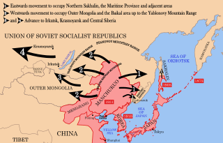
English: Strategic map of "Hoshukin-ron", the Japanese plans for a potential attack on the Soviet Union.
English: A map of the Imperial Powers of the Pacific, 1939-09-01. Dates shown indicate the approximate year that the various powers gain control of their possessions. Japanese control of territory in China was tenuous.
English: A Pacific-centered Mercator projection of the world with countries filled. Created in R using:
library(maps)
|
| تاریخ | (UTC) |
| قایناق | |
| یازار |
| این یک عکس دستکاری شده است به این معنی که به صورت دیجیتالی از نسخهٔ اصلی تغییر یافتهاست. تغییرها: Redrawn as vector image. اصل آن را میتوان در اینجا مشاهده کرد: Pacific Area - The Imperial Powers 1939 - Map.jpg. تغییرها توسط Begoon انجام شدهاست.
|
بو فایل کریتیو کامانز مجوز ایله Attribution-Share Alike 3.0 اویغونلاشمامیش یاییملانیبدیر.
- سیزین ایجازه نیز وار دیر:
- بؤلۆشمک – اثرین کپی، پایلاشماق و چاتدیرماسی اوچون
- تلفیق ائت – اثرین توتوشدورماسی اوچون
- آشاغی داکی شرایطله:
- تخصیص – اثری مؤلف و یا لیسئنزییالی طرفیندن گؤستریلدیی کیمی ایستیناد ائتملیسینیز (آنجاق سنی دستکلدیینی و یا اثردن ایستیفاده ائتمیینیزی تکلیف ائتمملیسینیز).
- بیرگه پایلاشیم – اگر بو اثرده دَییشدیرمه، چؤندرمه، یا دا کؤکدن دوزلتمه ائتسز، اله گلمیش اثری یالنیز بیر ائشیت یوخسا اوخشار بیر مجوزین آلتیندا یاییملایابیلرسینیز .
اورجینال یوکلمه گوندهلیگی
This image is a derivative work of the following images:
- File:Hokushin-ron-Map.png licensed with Cc-by-sa-3.0, GFDL
- 2010-08-26T14:40:14Z Begoon 1013x615 (185183 Bytes) remove headline/tweak type
- 2010-01-13T18:41:06Z 36ophiuchi 1013x615 (248571 Bytes) Fixed some minor errors.
- 2010-01-11T23:12:35Z 36ophiuchi 1013x615 (246326 Bytes) {{Information |Description={{en|1=Strategic map of "Hoshukin-ron", the Japanese plans for a potential attack on the Soviet Union.}} |Source=*[[:File:Pacific_Area_-_The_Imperial_Powers_1939_-_Map.svg|]] |Date=2010-01-11 23:11
- File:Pacific_Area_-_The_Imperial_Powers_1939_-_Map.svg licensed with Cc-by-sa-3.0, GFDL
- 2010-08-27T15:13:24Z Splittist 1039x814 (4653684 Bytes) There's no need to create a new file. The map description shows that this map deviates from the one from which it originated: many borders were modified: e.x. East Timor, Mengjiang. It also welcomes changes based on better in
- 2010-08-27T10:11:31Z Kintetsubuffalo 1039x814 (4658296 Bytes) then you are welcome to create your own file, rather than editwarring
- 2010-08-27T06:54:08Z Splittist 1039x814 (4653684 Bytes) Well that map (not the govt, a military academy; and by no means are maps on the area consistent in borders) is wrong. Sheng Shicai, who pledged allegiance to China, controlled Xinjiang in 1939. Marking Xinjiang as separate i
- 2010-08-27T03:36:43Z Kintetsubuffalo 1039x814 (4658296 Bytes) the US government map this is based on shows it as separate
- 2010-08-27T01:26:43Z Splittist 1039x814 (4653684 Bytes) No reason for Xinjiang to have separate borders from China
- 2009-05-31T02:33:19Z Kmusser 1039x814 (4658296 Bytes) add macau, fix marianas, hainan spelling
- 2008-10-30T15:20:49Z Valentim 1039x814 (4703043 Bytes) Reverted to version as of 05:16, 22 September 2008. The international name is "Sea of Japan".
- 2008-09-24T07:42:22Z 쿠도군 1039x814 (4704268 Bytes) Reverted to version as of 07:53, 11 September 2008
- 2008-09-22T05:16:58Z Chris 73 1039x814 (4703043 Bytes) Reverted to version as of 02:54, 21 August 2008
- 2008-09-11T07:53:32Z 쿠도군 1039x814 (4704268 Bytes) new version.
- 2008-08-21T02:54:43Z Emok 1039x814 (4703043 Bytes) {{Information |Description= |Source= |Date= |Author= |Permission= |other_versions= }}
- 2008-08-21T02:44:29Z Emok 1039x814 (4702923 Bytes) {{Information |Description= |Source= |Date= |Author= |Permission= |other_versions= }}
- 2008-08-08T01:16:33Z Emok 1039x814 (4678233 Bytes) {{Information |Description= |Source= |Date= |Author= |Permission= |other_versions= }}
- 2008-08-08T00:07:48Z Emok 1039x814 (4669659 Bytes) {{Information |Description= |Source= |Date= |Author= |Permission= |other_versions= }}
- 2008-08-07T05:03:23Z Emok 1039x814 (4669195 Bytes) {{Information |Description= |Source= |Date= |Author= |Permission= |other_versions= }}
- 2008-08-07T04:28:58Z Emok 1039x814 (4623405 Bytes) {{Information |Description= |Source= |Date= |Author= |Permission= |other_versions= }}
- 2008-08-07T04:02:57Z Emok 1039x814 (4602891 Bytes) {{Information |Description= |Source= |Date= |Author= |Permission= |other_versions= }}
- 2008-08-07T03:24:03Z Emok 1039x814 (4669511 Bytes) {{Information |Description= |Source= |Date= |Author= |Permission= |other_versions= }}
- 2008-08-04T16:59:39Z Emok 1039x814 (6442489 Bytes) {{Information |Description= |Source= |Date= |Author= |Permission= |other_versions= }}
- 2008-08-04T05:38:24Z Emok 1039x814 (6427678 Bytes) {{Information |Description= |Source= |Date= |Author= |Permission= |other_versions= }} [[Category:Imperialism]] [[Category:Oceania]]
- 2008-08-04T05:26:00Z Emok 104x82 (4765313 Bytes) {{Information |Description={{en|1=A map of the Imperial Powers of the Pacific, 1939-09-01. }} |Source=*[[:Image:World2Hires_filled_mercator.svg|]] |Date=2008-08-04 05:22 (UTC) |Author=*derivative work: ~~~ *[[:Image:World2Hir
- File:World2Hires_filled_mercator.svg licensed with Cc-by-sa-3.0, GFDL
- 2008-08-03T06:38:19Z Emok 220x171 (12002488 Bytes) {{Information |Description= |Source= |Date= |Author= |Permission= |other_versions= }} [[Category:Blank SVG maps of the world]]
- 2008-08-03T06:00:29Z Emok 520x519 (3064180 Bytes) {{Information |Description={{en|1=A Pacific-centered Mercator projection of the world with countries filled.}} |Source=Own work by uploader |Author=[[User:Emok|Emok]] |Date=2008-08-01 |Permission= |other_versions= }} {{Image
- File:Pacific_Area_-_The_Imperial_Powers_1939_-_Map.jpg licensed with PD-USGov-Military-Army
Uploaded with derivativeFX
فايل گئچمیشی
فايلین اولکی وئرسیياسینی گؤرمک اۆچون گۆن/تاریخ بؤلمهسیندهکی تاریخلری تێقلايین.
| تاریخ/واخت | کیچیک عکس | اؤلچولر | ایشلدن | باخیش | |
|---|---|---|---|---|---|
| ایندیکی | ۱۶ ژانویه ۲۰۱۲، ساعت ۰۳:۳۷ | | ۱٬۰۳۸ در ۶۶۴ (۶۴۹ کیلوبایت) | Quigley | Xinjiang wasn't separate from China |
| ۲۹ آقوست ۲۰۱۰، ساعت ۰۵:۴۰ |  | ۱٬۰۳۸ در ۶۶۴ (۶۵۳ کیلوبایت) | Begoon | emphasise relevant font weights | |
| ۲۸ آقوست ۲۰۱۰، ساعت ۱۰:۰۴ |  | ۱٬۰۳۸ در ۶۶۴ (۶۲۸ کیلوبایت) | Begoon | you'd think a mountain range would be big enough not to miss - fixed font for last one... | |
| ۲۸ آقوست ۲۰۱۰، ساعت ۱۰:۰۰ |  | ۱٬۰۳۸ در ۶۶۴ (۶۲۶ کیلوبایت) | Begoon | font weight for Mountain ranges/Pt Arthur | |
| ۲۸ آقوست ۲۰۱۰، ساعت ۰۹:۴۳ |  | ۱٬۰۳۸ در ۶۶۴ (۶۱۹ کیلوبایت) | Begoon | {{Information |Description={{en|1=Strategic map of "Hoshukin-ron", the Japanese plans for a potential attack on the Soviet Union.}} {{en|1=A map of the Imperial Powers of the Pacific, 1939-09-01. Dates shown indicate the approximate year that the various |
فايل ایشلدمهسی
آشاغیداکی صحیفه بو فایلا باغلانیر
فایلین باشاباش ایشلنیلمهسی
بو فایل آشاغی داکی آیری ویکی لرده ایشلَنیر:
- az.wikipedia.org-ده ایشلنمهسی
- bg.wikipedia.org-ده ایشلنمهسی
- en.wikipedia.org-ده ایشلنمهسی
- es.wikipedia.org-ده ایشلنمهسی
- fa.wikipedia.org-ده ایشلنمهسی
- fr.wikipedia.org-ده ایشلنمهسی
- he.wikipedia.org-ده ایشلنمهسی
- id.wikipedia.org-ده ایشلنمهسی
- it.wikipedia.org-ده ایشلنمهسی
- ja.wikipedia.org-ده ایشلنمهسی
- ko.wikipedia.org-ده ایشلنمهسی
- mn.wikipedia.org-ده ایشلنمهسی
- ms.wikipedia.org-ده ایشلنمهسی
- no.wikipedia.org-ده ایشلنمهسی
- pt.wikipedia.org-ده ایشلنمهسی
- ru.wikipedia.org-ده ایشلنمهسی
- uk.wikipedia.org-ده ایشلنمهسی
- www.wikidata.org-ده ایشلنمهسی
- zh.wikipedia.org-ده ایشلنمهسی