فایل:Illinois 1718.jpg

سیناق گؤستریشی اؤلچوسو: ۴۷۹ × ۵۹۹ پیکسل. آیری کیفیتلر: ۱۹۲ × ۲۴۰ پیکسل | ۵۸۹ × ۷۳۷ پیکسل.
فایلین اصلی (۵۸۹ × ۷۳۷ پیکسل, فایل اؤلچوسو: ۲۳۲ کیلوبایت, MIME نوعو: image/jpeg)
قیساسی
| آچیقلاما |
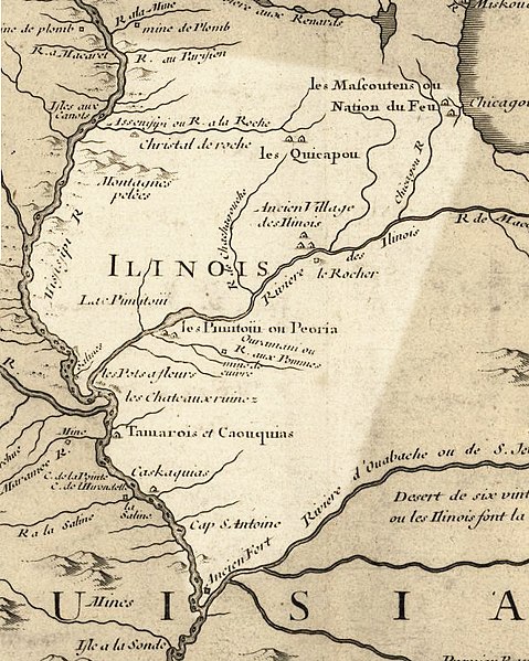
English: Illinois in 1718, approximate modern state area highlighted, from Carte de la Louisiane et du cours du Mississipi by Guillaume de L'Isle. This map shows Chicago as being the strategic point of connection between the Great Lakes and the Mississippi River Basin. |
|||||||||||||||||||||||
| تاریخ | (rev. 2009) | |||||||||||||||||||||||
| قایناق |
|
|||||||||||||||||||||||
| یازار |
|
|||||||||||||||||||||||
| ایجازه (فایلین تکرار ایستیفادهسی) |
US Govt Public Domain, also author +100 years | |||||||||||||||||||||||

لیسانس
|
این اثر در کشورهایی و مناطقی که مدت زمان حق تکثیر، عمر پدیدآورنده بعلاوه 100 سال یا کمتر بعد از مرگ او است، در مالکیت عمومی قرار دارد. | |
| این پرونده تحت قانون حق تکثیر محدودیت آزاد منتشر شده که شامل تمامی حقوق مربوطه و حقوق نزدیک به آن میشود. | |
اورجینال یوکلمه گوندهلیگی
The original description page was here. All following user names refer to en.wikipedia.
- 2009-07-25 15:17 Billwhittaker 589×737× (237103 bytes) {{Information |Description = Illinois in 1718, approximate modern state area highlighted, from ''Carte de la Louisiane et du cours du Mississipi'' by [[Guillaume de L'Isle]]. |Source = Library of Congress Public Domain Site: http://hdl.loc.go
فايل گئچمیشی
فايلین اولکی وئرسیياسینی گؤرمک اۆچون گۆن/تاریخ بؤلمهسیندهکی تاریخلری تێقلايین.
| تاریخ/واخت | کیچیک عکس | اؤلچولر | ایشلدن | باخیش | |
|---|---|---|---|---|---|
| ایندیکی | ۲۱ سپتامبر ۲۰۰۹، ساعت ۱۹:۴۲ | | ۵۸۹ در ۷۳۷ (۲۳۲ کیلوبایت) | Jeangagnon | {{Information |Description={{en|Illinois in 1718, approximate modern state area highlighted, from ''Carte de la Louisiane et du cours du Mississipi'' by en:Guillaume de L'Isle.}} |Source=Transferred from [http://en.wikipedia.org en.wikipedia]<br/> ( |
فايل ایشلدمهسی
بو فایلا هئچ بیر صفحهیه باغلانماییب.
فایلین باشاباش ایشلنیلمهسی
بو فایل آشاغی داکی آیری ویکی لرده ایشلَنیر:
- ar.wikipedia.org-ده ایشلنمهسی
- arz.wikipedia.org-ده ایشلنمهسی
- bg.wikipedia.org-ده ایشلنمهسی
- en.wikipedia.org-ده ایشلنمهسی
- en.wikibooks.org-ده ایشلنمهسی
- es.wikipedia.org-ده ایشلنمهسی
- he.wikipedia.org-ده ایشلنمهسی
- ja.wikipedia.org-ده ایشلنمهسی
- pt.wikipedia.org-ده ایشلنمهسی
- ru.wikipedia.org-ده ایشلنمهسی
- uk.wikipedia.org-ده ایشلنمهسی