فایل:India1765and1805b.jpg

سیناق گؤستریشی اؤلچوسو: ۷۷۴ × ۵۹۹ پیکسل. آیری کیفیتلر: ۳۱۰ × ۲۴۰ پیکسل | ۶۲۰ × ۴۸۰ پیکسل | ۹۹۲ × ۷۶۸ پیکسل | ۱٬۲۲۷ × ۹۵۰ پیکسل.
فایلین اصلی (۱٬۲۲۷ × ۹۵۰ پیکسل, فایل اؤلچوسو: ۳۰۷ کیلوبایت, MIME نوعو: image/jpeg)
قیساسی
| آچیقلاما |
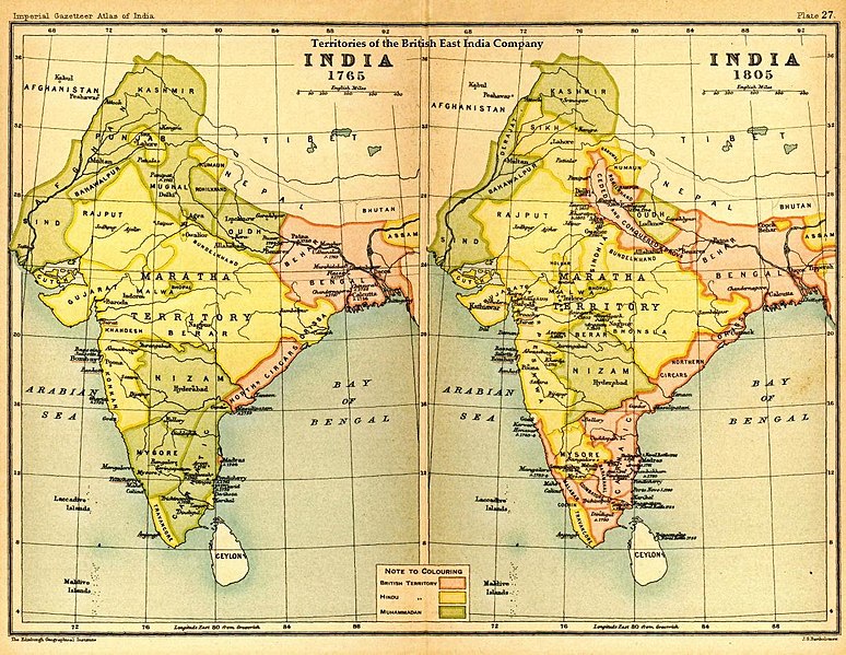
English: Map of India under the British East India Company, comparing 1765 and 1805 |
|||||
| تاریخ | ||||||
| قایناق | Imperial Gazetteer of India, Secretary of State for India, OUP, 1907. Scanned from personal copy Fowler&fowler, 22:32, 29 August 2007 (UTC) | |||||
| یازار | Edinburgh Geographical Institute. | |||||
| ایجازه (فایلین تکرار ایستیفادهسی) |
|

اورجینال یوکلمه گوندهلیگی
The original description page was here. All following user names refer to en.wikipedia.
- 2010-04-18 16:17 Beao 1227×950× (314652 bytes) Removed watermark.
- 2007-08-29 22:32 Fowler&fowler 1227×950× (284253 bytes) == Summary == Image of map of India under the British East India Company from Imperial Gazetteer of India,Oxford University Press, 1907. Scanned and reduced from personal copy by ~~~~ {{PD-old-70}} ==Licensing== {{PD-US-1923-abroad}}
فايل گئچمیشی
فايلین اولکی وئرسیياسینی گؤرمک اۆچون گۆن/تاریخ بؤلمهسیندهکی تاریخلری تێقلايین.
| تاریخ/واخت | کیچیک عکس | اؤلچولر | ایشلدن | باخیش | |
|---|---|---|---|---|---|
| ایندیکی | ۵ آقوست ۲۰۱۷، ساعت ۲۲:۰۸ | | ۱٬۲۲۷ در ۹۵۰ (۳۰۷ کیلوبایت) | OgreBot | (BOT): Reverting to most recent version before archival |
| ۵ آقوست ۲۰۱۷، ساعت ۲۲:۰۸ |  | ۱٬۲۲۷ در ۹۵۰ (۲۷۸ کیلوبایت) | OgreBot | (BOT): Uploading old version of file from en.wikipedia; originally uploaded on 2007-08-29 22:32:42 by Fowler&fowler | |
| ۳۰ آوریل ۲۰۱۳، ساعت ۱۶:۰۶ |  | ۱٬۲۲۷ در ۹۵۰ (۳۰۷ کیلوبایت) | Gz deleted | {{Information |Description=Indian map |Source=en wiki |Date=unknown |Author=unknown |Permission={{GFDL-user-w|||User:Fowler&fowler}} |other_versions= }} |
فايل ایشلدمهسی
آشاغیداکی صحیفه بو فایلا باغلانیر
فایلین باشاباش ایشلنیلمهسی
بو فایل آشاغی داکی آیری ویکی لرده ایشلَنیر:
- ar.wikipedia.org-ده ایشلنمهسی
- cs.wikipedia.org-ده ایشلنمهسی
- de.wikiversity.org-ده ایشلنمهسی
- el.wikipedia.org-ده ایشلنمهسی
- en.wikipedia.org-ده ایشلنمهسی
- es.wikipedia.org-ده ایشلنمهسی
- fa.wikipedia.org-ده ایشلنمهسی
- fr.wikipedia.org-ده ایشلنمهسی
- incubator.wikimedia.org-ده ایشلنمهسی
- ne.wikipedia.org-ده ایشلنمهسی
- pa.wikipedia.org-ده ایشلنمهسی
- pnb.wikipedia.org-ده ایشلنمهسی
- pt.wikipedia.org-ده ایشلنمهسی
- sl.wikipedia.org-ده ایشلنمهسی
- ta.wikipedia.org-ده ایشلنمهسی
- te.wikipedia.org-ده ایشلنمهسی
- th.wikipedia.org-ده ایشلنمهسی
- ur.wikipedia.org-ده ایشلنمهسی
- www.wikidata.org-ده ایشلنمهسی