فایل:Ionian Revolt Campaign Map.png
سیناق گؤستریشی اؤلچوسو: ۴۹۳ × ۵۹۹ پیکسل. آیری کیفیتلر: ۱۹۷ × ۲۴۰ پیکسل | ۳۹۵ × ۴۸۰ پیکسل | ۶۳۲ × ۷۶۸ پیکسل | ۸۴۲ × ۱٬۰۲۴ پیکسل | ۱٬۶۴۵ × ۲٬۰۰۰ پیکسل.
فایلین اصلی (۱٬۶۴۵ × ۲٬۰۰۰ پیکسل, فایل اؤلچوسو: ۴٫۲۴ مگابایت, MIME نوعو: image/png)
| آچیقلاما |
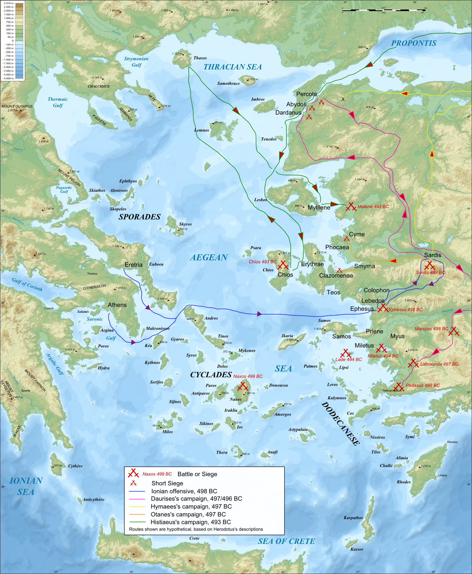
English: Bathymetric/Topographical map of the Aegean area in c.500 BC, showing major events of the Ionian Revolt.
|
| تاریخ | (UTC) |
| قایناق | |
| یازار |
|
| آیری نوسخهلر |
|


| این یک عکس دستکاری شده است به این معنی که به صورت دیجیتالی از نسخهٔ اصلی تغییر یافتهاست. تغییرها: Modified map to more ancient names, and constructed campaign map of Ionina revolt. اصل آن را میتوان در اینجا مشاهده کرد: Aegean Sea map bathymetry-fr.svg. تغییرها توسط MinisterForBadTimes انجام شدهاست.
|
من، صاحب حقوق قانونی این اثر، به این وسیله این اثر را تحث اجازهنامههای ذیل منتشر میکنم:
این پرونده با اجازهنامهٔ کریتیو کامانز Attribution-Share Alike 3.0 سازگار نشده، 2.5 عمومی، 2.0 عمومی و 1.0 عمومی منتشر شده است.
- سیزین ایجازه نیز وار دیر:
- بؤلۆشمک – اثرین کپی، پایلاشماق و چاتدیرماسی اوچون
- تلفیق ائت – اثرین توتوشدورماسی اوچون
- آشاغی داکی شرایطله:
- تخصیص – اثری مؤلف و یا لیسئنزییالی طرفیندن گؤستریلدیی کیمی ایستیناد ائتملیسینیز (آنجاق سنی دستکلدیینی و یا اثردن ایستیفاده ائتمیینیزی تکلیف ائتمملیسینیز).
- بیرگه پایلاشیم – اگر بو اثرده دَییشدیرمه، چؤندرمه، یا دا کؤکدن دوزلتمه ائتسز، اله گلمیش اثری یالنیز بیر ائشیت یوخسا اوخشار بیر مجوزین آلتیندا یاییملایابیلرسینیز .

|
اجازهٔ کپی، پخش و/یا تغییر این سند تحت شرایط مجوز مستندات آزاد گنو، نسخهٔ ۱٫۲ یا هر نسخهٔ بعدتری که توسط بنیاد نرمافزار آزاد منتشر شده؛ بدون بخشهای ناوردا (نامتغیر)، متون روی جلد، و متون پشت جلد، اعطا میشود. یک کپی از مجوز در بخشی تحت عنوان مجوز مستندات آزاد گنو ضمیمه شده است.
بو فایلین،
کوپیالانماسی، پایلانماسی و / و یا دییشدیریلمهسینه ایجازه وئریلمیشدیر. لیسئنزیانین بیر کوپیاسی،مجوز مستندات آزاد گنوباشلیقلی حیسهده ایشتیراک ائتمکدهدیر. |
ایستدیگینیز لیسئنزیانی سئچه بیلرسینیز.
اورجینال یوکلمه گوندهلیگی
This image is a derivative work of the following images:
- File:Aegean_Sea_map_bathymetry-fr.svg licensed with Cc-by-sa-3.0,2.5,2.0,1.0, GFDL
- 2009-02-08T00:35:16Z Sting 3750x4560 (3597775 Bytes) Correcting display bug - new try - step #2
- 2009-02-08T00:29:02Z Sting 3750x4560 (410188 Bytes) Correcting display bug - new try - step #1
- 2009-02-08T00:14:50Z Sting 3750x4560 (3740562 Bytes) Correcting display bug
- 2009-02-06T07:54:54Z Future Perfect at Sunrise 3750x4560 (3742390 Bytes) null edit, re-uploading to try to force display to be reset, background image wasn't displaying
- 2009-02-06T07:52:12Z Future Perfect at Sunrise 3750x4560 (3742390 Bytes) null edit, re-uploading to try to force display to be reset, background image wasn't displaying
- 2008-09-28T21:11:49Z Sting 3750x4560 (3742390 Bytes) Completely new background using ETOPO1 data ; new standard colors ; some additional labels
- 2007-11-27T13:16:40Z Sting 3750x4560 (4078448 Bytes) Elevation on Chios
- 2007-11-26T23:25:43Z Sting 3750x4560 (4078446 Bytes) correction
- 2007-11-21T22:42:53Z Sting 3750x4560 (4079234 Bytes) Additional sea names
- 2007-11-21T20:21:26Z Sting 3750x4560 (4078039 Bytes) Additional key
- 2007-11-21T19:10:35Z Sting 3750x4560 (4072878 Bytes) {{Information |Description=Bathymetric map in French of the [[:Category:Aegean Sea|Aegean Sea]], Mediterranean Sea |Source=Own work ;Raster relief background map : [http://www2.jpl.nasa.gov/srtm NASA Shuttle Radar Topography
Uploaded with derivativeFX
فايل گئچمیشی
فايلین اولکی وئرسیياسینی گؤرمک اۆچون گۆن/تاریخ بؤلمهسیندهکی تاریخلری تێقلايین.
| تاریخ/واخت | کیچیک عکس | اؤلچولر | ایشلدن | باخیش | |
|---|---|---|---|---|---|
| ایندیکی | ۲۳ آوریل ۲۰۰۹، ساعت ۰۶:۳۵ | | ۱٬۶۴۵ در ۲٬۰۰۰ (۴٫۲۴ مگابایت) | MinisterForBadTimes | {{Information |Description=40px '''Note:''' this SVG map has a display bug on this page (size too large?) but works fine in Inkscape. Consider using the raster version in the art |
فايل ایشلدمهسی
آشاغیداکی 3 صحیفهلر بو فایلا باغلانیرلار
فایلین باشاباش ایشلنیلمهسی
بو فایل آشاغی داکی آیری ویکی لرده ایشلَنیر:
- ca.wikipedia.org-ده ایشلنمهسی
- el.wikipedia.org-ده ایشلنمهسی
- en.wikipedia.org-ده ایشلنمهسی
- eu.wikipedia.org-ده ایشلنمهسی
- fa.wikipedia.org-ده ایشلنمهسی
- fr.wikipedia.org-ده ایشلنمهسی
- hr.wikipedia.org-ده ایشلنمهسی
- hy.wikipedia.org-ده ایشلنمهسی
- id.wikipedia.org-ده ایشلنمهسی
- it.wikipedia.org-ده ایشلنمهسی
- it.wikiversity.org-ده ایشلنمهسی
- ko.wikipedia.org-ده ایشلنمهسی
- pl.wikipedia.org-ده ایشلنمهسی
- pnb.wikipedia.org-ده ایشلنمهسی
- pt.wikipedia.org-ده ایشلنمهسی
- ru.wikipedia.org-ده ایشلنمهسی
- sh.wikipedia.org-ده ایشلنمهسی
- ta.wikipedia.org-ده ایشلنمهسی
- tr.wikipedia.org-ده ایشلنمهسی
- uk.wikipedia.org-ده ایشلنمهسی
- ur.wikipedia.org-ده ایشلنمهسی
- zh.wikipedia.org-ده ایشلنمهسی