فایل:Karte Eroberung Konstantinopel 1453.png

سیناق گؤستریشی اؤلچوسو: ۷۵۰ × ۶۰۰ پیکسل. آیری کیفیتلر: ۳۰۰ × ۲۴۰ پیکسل | ۶۰۰ × ۴۸۰ پیکسل | ۹۶۰ × ۷۶۸ پیکسل | ۱٬۲۸۰ × ۱٬۰۲۴ پیکسل | ۲٬۵۰۰ × ۲٬۰۰۰ پیکسل.
فایلین اصلی (۲٬۵۰۰ × ۲٬۰۰۰ پیکسل, فایل اؤلچوسو: ۱٫۱۸ مگابایت, MIME نوعو: image/png)
قیساسی
| آچیقلاما |
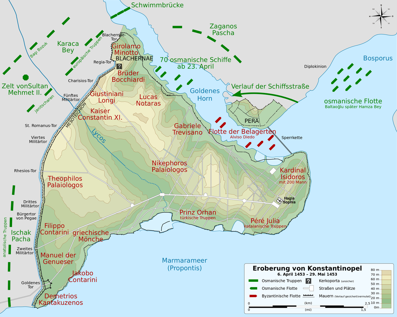
English: Map of the Ottoman and Byzantine forces during the siege of Constantinople, from 6 April 1453 to 29 May 1453. French version. Français : Carte des forces ottomanes et byzantines lors du siège de Constantinople, du 6 avril 1453 au 29 mai 1453. Deutsch: Topografische Karte Konstantinopels während des byzantinischen Zeitraums. Quelle: R. Janin, Constantinople Byzantine. Developpement urbain et repertoire topographique. Straßennetz und andere Einzelheiten basiert auf Dumbarton Oaks Papers 54. Kirchen, insb. nicht identifizierte und ausgegrabene Bauten sind aus dem The Byzantine Churches of Istanbul entnommen. Andere herausgegebenen Quellen wurden behilfsmäßig gebraucht. English: Topographical map of Constantinople during the Byzantine period. Main map source: R. Janin, Constantinople Byzantine. Developpement urbain et repertoire topographique. Road network and some other details based on Dumbarton Oaks Papers 54; data on many churches, especially unidentified ones, taken from the University of New York's The Byzantine Churches of Istanbul project. Other published maps and accounts of the city have been used for corroboration. Français : Carte en anglais de Constantinople à l'époque Byzantine. Source principale : R. Janin, Constantinople Byzantine. Développement urbain et répertoire topographique. Le réseau routier et d'autres détails proviennent de Dumbarton Oaks Papers 54. Les données concernant de nombreuses églises, en particulier celles non identifiées, viennent de l'université de New York : le projet The Byzantine Churches of Istanbul (Les églises byzantines d'Istanbul). D'autres cartes encore ont été utilisées pour recouper et vérifier les informations. Türkçe: tr:Konstantinopolis'in Bizans dönemindeki topografik haritası. Ana haritanın kaynağı: R. Janin, Constantinople Byzantine. Developpement urbain et repertoire topographique. Yol haritası ve bazı diğer ayrıntıların kaynağı: Dumbarton Oaks Papers 54; kiliseler, özellikle kimliği belirlenmemiş olanlar hakkında veriler, New York University'nin İstanbul'un Bizans Kiliseleri projesinden elde edilmiştir. Şehir hakkında yayımlanmış diğer harita ve metinler bu bilgileri doğrulamak için kullanılmıştır. Ελληνικά: Τοπογραφικός χάρτης Κωνσταντινουπόλεως κατά τη Βυζαντινή περίοδο. Βασική πηγή χάρτη: R. Janin, Constantinople Byzantine. Developpement urbain et repertoire topographique. Το οδικό δίκτυο και διάφορες άλλες λεπτομέρειες με βάση το Dumbarton Oaks Papers 54. Πληροφορίες για τις εκκλησίες, ιδιαίτερα τις μη ταυτοποιημένες, από την ιστοσελίδα The Byzantine Churches of Istanbul του Πανεπιστημίου της Νέας Υόρκης. Български: Топографска карта на Константинопол (Цариград) през византийския период. Източник: R. Janin, Constantinople Byzantine. Developpement urbain et repertoire topographique. Пътната мрежа и някои други детайли се основават на Dumbarton Oaks Papers 54 и други публикувани източници. English: Map of the Ottoman and Byzantine forces during the siege of Constantinople, from 6 April 1453 to 29 May 1453. French version. Français : Carte des forces ottomanes et byzantines lors du siège de Constantinople, du 6 avril 1453 au 29 mai 1453. Deutsch: Topografische Karte Konstantinopels während des byzantinischen Zeitraums. Quelle: R. Janin, Constantinople Byzantine. Developpement urbain et repertoire topographique. Straßennetz und andere Einzelheiten basiert auf Dumbarton Oaks Papers 54. Kirchen, insb. nicht identifizierte und ausgegrabene Bauten sind aus dem The Byzantine Churches of Istanbul entnommen. Andere herausgegebenen Quellen wurden behilfsmäßig gebraucht. English: Topographical map of Constantinople during the Byzantine period. Main map source: R. Janin, Constantinople Byzantine. Developpement urbain et repertoire topographique. Road network and some other details based on Dumbarton Oaks Papers 54; data on many churches, especially unidentified ones, taken from the University of New York's The Byzantine Churches of Istanbul project. Other published maps and accounts of the city have been used for corroboration. Français : Carte en anglais de Constantinople à l'époque Byzantine. Source principale : R. Janin, Constantinople Byzantine. Développement urbain et répertoire topographique. Le réseau routier et d'autres détails proviennent de Dumbarton Oaks Papers 54. Les données concernant de nombreuses églises, en particulier celles non identifiées, viennent de l'université de New York : le projet The Byzantine Churches of Istanbul (Les églises byzantines d'Istanbul). D'autres cartes encore ont été utilisées pour recouper et vérifier les informations. Türkçe: tr:Konstantinopolis'in Bizans dönemindeki topografik haritası. Ana haritanın kaynağı: R. Janin, Constantinople Byzantine. Developpement urbain et repertoire topographique. Yol haritası ve bazı diğer ayrıntıların kaynağı: Dumbarton Oaks Papers 54; kiliseler, özellikle kimliği belirlenmemiş olanlar hakkında veriler, New York University'nin İstanbul'un Bizans Kiliseleri projesinden elde edilmiştir. Şehir hakkında yayımlanmış diğer harita ve metinler bu bilgileri doğrulamak için kullanılmıştır. Ελληνικά: Τοπογραφικός χάρτης Κωνσταντινουπόλεως κατά τη Βυζαντινή περίοδο. Βασική πηγή χάρτη: R. Janin, Constantinople Byzantine. Developpement urbain et repertoire topographique. Το οδικό δίκτυο και διάφορες άλλες λεπτομέρειες με βάση το Dumbarton Oaks Papers 54. Πληροφορίες για τις εκκλησίες, ιδιαίτερα τις μη ταυτοποιημένες, από την ιστοσελίδα The Byzantine Churches of Istanbul του Πανεπιστημίου της Νέας Υόρκης. Български: Топографска карта на Константинопол (Цариград) през византийския период. Източник: R. Janin, Constantinople Byzantine. Developpement urbain et repertoire topographique. Пътната мрежа и някои други детайли се основават на Dumbarton Oaks Papers 54 и други публикувани източници. |
| تاریخ | (UTC) |
| قایناق |
این پرونده مشتق شدهاست از: |
| یازار |
| این یک عکس دستکاری شده است به این معنی که به صورت دیجیتالی از نسخهٔ اصلی تغییر یافتهاست. تغییرها: Übersetzung ins Deutsche und kleine Ergänzungen; als PNG. اصل آن را میتوان در اینجا مشاهده کرد: Byzantine Constantinople-en.svg. تغییرها توسط Lokiseinchef انجام شدهاست.
|
لیسانس
بو فایل کریتیو کامانز مجوز ایله Attribution-Share Alike 3.0 اویغونلاشمامیش یاییملانیبدیر.
- سیزین ایجازه نیز وار دیر:
- بؤلۆشمک – اثرین کپی، پایلاشماق و چاتدیرماسی اوچون
- تلفیق ائت – اثرین توتوشدورماسی اوچون
- آشاغی داکی شرایطله:
- تخصیص – اثری مؤلف و یا لیسئنزییالی طرفیندن گؤستریلدیی کیمی ایستیناد ائتملیسینیز (آنجاق سنی دستکلدیینی و یا اثردن ایستیفاده ائتمیینیزی تکلیف ائتمملیسینیز).
- بیرگه پایلاشیم – اگر بو اثرده دَییشدیرمه، چؤندرمه، یا دا کؤکدن دوزلتمه ائتسز، اله گلمیش اثری یالنیز بیر ائشیت یوخسا اوخشار بیر مجوزین آلتیندا یاییملایابیلرسینیز .
اورجینال یوکلمه گوندهلیگی
This image is a derivative work of the following images:
- File:Karte_Eroberung_Konstantinopels_1453.svg licensed with Cc-by-sa-3.0
- 2013-04-07T20:45:38Z Lokiseinchef 2500x2000 (212692 Bytes) mit Beschriftung
- 2013-04-07T20:41:54Z Lokiseinchef 2500x2000 (212716 Bytes) == {{int:filedesc}} == {{Information |Description={{Multilingual description |en= Map of the Ottoman and Byzantine forces during the [[:en:Fall of Constantinople|siege of Constantinople]], from 6 April 1453 to 29 May 1453. Fr
- File:Siege_of_Constantinople_1453_map-fr.svg licensed with Cc-by-sa-3.0,2.5,2.0,1.0, FAL
- 2012-03-14T22:12:38Z Sémhur 2500x2000 (189952 Bytes) == {{int:filedesc}} == {{Information |Description={{Multilingual description |en= Map of the Ottoman and Byzantine forces during the [[:en:Fall of Constantinople|siege of Constantinople]], from 6 April 1453 to 29 May 1453. Fr
- File:Byzantine_Constantinople.svg licensed with Cc-by-sa-3.0, GFDL
- 2012-03-13T20:48:46Z Sémhur 2085x1889 (3867401 Bytes) New version, with cleaned code and a new layer "editable text, hidden" made with font "Nimbus Sans L", containing all the texts, and other layers with text as path (not editables, but visibles).
- 2009-12-15T13:13:22Z Cplakidas 2050x1850 (8520961 Bytes) larger & improved version, various corrections, Galata included
- 2009-01-08T22:53:05Z Cplakidas 1600x1500 (6068684 Bytes) {{Information |Description= |Source= |Date= |Author= |Permission= |other_versions= }}
- 2008-11-14T23:26:35Z Cplakidas 1600x1500 (5550805 Bytes) attempt to get text right
- 2008-10-28T11:38:36Z Cplakidas 1600x1500 (5570026 Bytes) final version (hopefully): added remaining churches & corrected locations, minor tweaks at places
- 2008-10-27T19:10:38Z Cplakidas 1600x1500 (5044456 Bytes) completed outer land wall, fixed Golden Gate, fixed sea walls & added known gates, minor location corrections & additions
- 2008-10-25T17:46:57Z Cplakidas 1600x1500 (2868866 Bytes) text into paths, enlarged map for improved readability
- 2008-10-24T00:59:09Z Cplakidas 1180x1120 (380180 Bytes) restored Times New Roman.
- 2008-10-24T00:39:44Z Cplakidas 1180x1120 (377994 Bytes) added posterns, alternate gate names, approx. roads in outer city, corrections on monastery locations, converted text to sans serif font
- 2008-10-23T22:47:55Z Cplakidas 1180x1120 (335598 Bytes) Reverted to version as of 23:25, 14 October 2008
- 2008-10-23T22:45:25Z Cplakidas 1180x1120 (344657 Bytes) added posterns, alternate gate names, approx. roads in outer city, minor tweaks
- 2008-10-14T23:25:51Z Cplakidas 1180x1120 (335598 Bytes) various tweaks & corrections, added some features
- 2008-10-14T12:19:50Z Cplakidas 1180x1120 (321445 Bytes) minor tweaks & corrections
- 2008-10-14T12:07:30Z Cplakidas 1180x1120 (324413 Bytes) minor tweaks & corrections
- 2008-10-13T23:23:57Z Cplakidas 1180x1120 (321907 Bytes) {{Information |Description={{en|1=Topographical map of [[Constantinople]] during the [[Byzantine Empire|Byzantine]] period. Map source: R. Janin, ''Constantinople Byzantine. Developpement urbain et repertoire topographique''.
Uploaded with derivativeFX
فايل گئچمیشی
فايلین اولکی وئرسیياسینی گؤرمک اۆچون گۆن/تاریخ بؤلمهسیندهکی تاریخلری تێقلايین.
| تاریخ/واخت | کیچیک عکس | اؤلچولر | ایشلدن | باخیش | |
|---|---|---|---|---|---|
| ایندیکی | ۱۳ آوریل ۲۰۱۳، ساعت ۰۸:۳۹ | | ۲٬۵۰۰ در ۲٬۰۰۰ (۱٫۱۸ مگابایت) | Lokiseinchef | == {{int:filedesc}} == {{Information |Description={{Multilingual description |en= Map of the Ottoman and Byzantine forces during the siege of Constantinople, from 6 April 1453 to 29 May 1453. French version. |fr= Carte de... |
فايل ایشلدمهسی
آشاغیداکی صحیفه بو فایلا باغلانیر
فایلین باشاباش ایشلنیلمهسی
بو فایل آشاغی داکی آیری ویکی لرده ایشلَنیر:
- de.wikipedia.org-ده ایشلنمهسی
- en.wikipedia.org-ده ایشلنمهسی
- ml.wikipedia.org-ده ایشلنمهسی