فایل:LOOKING SOUTH FROM BRIDGE AT CREEK - Big Bear Creek Covered Bridge, Allsboro, Colbert County, AL HABS ALA,17-ALBO.V,2-4.tif

حجم پیشنمایش JPG این TIF file:۸۰۰ × ۵۷۳ پیکسل آیری کیفیتلر: ۳۲۰ × ۲۲۹ پیکسل | ۶۴۰ × ۴۵۸ پیکسل | ۱٬۰۲۴ × ۷۳۳ پیکسل | ۱٬۲۸۰ × ۹۱۶ پیکسل | ۲٬۵۶۰ × ۱٬۸۳۲ پیکسل | ۵٬۰۰۰ × ۳٬۵۷۹ پیکسل.
فایلین اصلی (۵٬۰۰۰ × ۳٬۵۷۹ پیکسل, فایل اؤلچوسو: ۱۷٫۰۷ مگابایت, MIME نوعو: image/tiff)
قیساسی
| Historic American Buildings Survey Alex Bush, Photographer, April 29, 1936 LOOKING SOUTH FROM BRIDGE AT CREEK - Big Bear Creek Covered Bridge, Allsboro, Colbert County, AL | ||||
|---|---|---|---|---|
| باشلیق |
Historic American Buildings Survey Alex Bush, Photographer, April 29, 1936 LOOKING SOUTH FROM BRIDGE AT CREEK - Big Bear Creek Covered Bridge, Allsboro, Colbert County, AL |
|||
| محل تصویرشده | Alabama; Colbert County; Allsboro | |||
| تاریخ | Documentation compiled after 1933 | |||
| اورتا | 5 x 7 in. | |||
| ایندیکی یئری |
Library of Congress Prints and Photographs Division Washington, D.C. 20540 USA http://hdl.loc.gov/loc.pnp/pp.print |
|||
| آیدی |
HABS ALA,17-ALBO.V,2-4 |
|||
| اعتبار خطی |
|
|||
| نوتلار |
|
|||
| قایناق | https://www.loc.gov/pictures/item/al0070.photos.001616p | |||
| ایجازه (فایلین تکرار ایستیفادهسی) |
|
|||

| مختصات دوربین | | محل قرارگیری این نگاره و سایر نگارهها در: نقشهٔ شهری باز |
|---|
فايل گئچمیشی
فايلین اولکی وئرسیياسینی گؤرمک اۆچون گۆن/تاریخ بؤلمهسیندهکی تاریخلری تێقلايین.
| تاریخ/واخت | کیچیک عکس | اؤلچولر | ایشلدن | باخیش | |
|---|---|---|---|---|---|
| ایندیکی | ۲۷ ژوئن ۲۰۱۴، ساعت ۱۲:۴۴ | 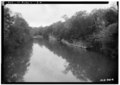 | ۵٬۰۰۰ در ۳٬۵۷۹ (۱۷٫۰۷ مگابایت) | Fæ | GWToolset: Creating mediafile for Fæ. HABS batch upload restart 26 June 2014 (p21:101)x |
فايل ایشلدمهسی
آشاغیداکی صحیفه بو فایلا باغلانیر
فایلین باشاباش ایشلنیلمهسی
بو فایل آشاغی داکی آیری ویکی لرده ایشلَنیر:
- en.wikipedia.org-ده ایشلنمهسی
- es.wikipedia.org-ده ایشلنمهسی
- www.wikidata.org-ده ایشلنمهسی