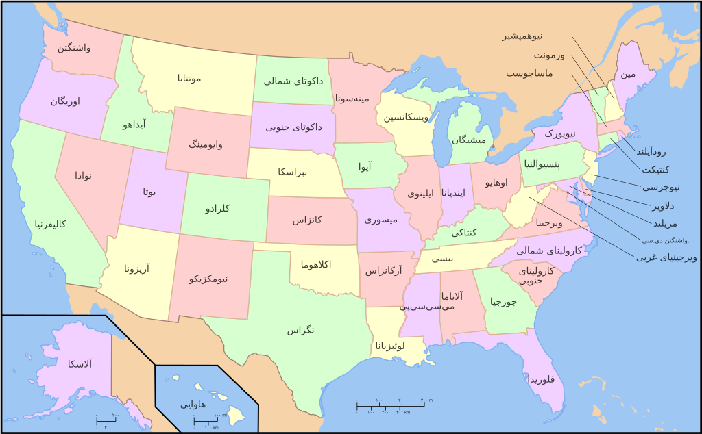
فایل:Map of USA with state names fa.svg

حجم پیشنمایش PNG این SVG file:۸۰۰ × ۴۹۵ پیکسل آیری کیفیتلر: ۳۲۰ × ۱۹۸ پیکسل | ۶۴۰ × ۳۹۶ پیکسل | ۱٬۰۲۴ × ۶۳۳ پیکسل | ۱٬۲۸۰ × ۷۹۱ پیکسل | ۲٬۵۶۰ × ۱٬۵۸۳ پیکسل | ۹۵۹ × ۵۹۳ پیکسل.
فایلین اصلی (SVG فایلی، ۹۵۹ × ۵۹۳ پیکسئل، فایلین اؤلچوسو: ۳۳۲ کیلوبایت)


.svg)


| این یک عکس دستکاری شده است به این معنی که به صورت دیجیتالی از نسخهٔ اصلی تغییر یافتهاست. تغییرها: Persian version. اصل آن را میتوان در اینجا مشاهده کرد: Map of USA with state names.svg. تغییرها توسط Ladsgroup انجام شدهاست.
|

|
اجازهٔ کپی، پخش و/یا تغییر این سند تحت شرایط مجوز مستندات آزاد گنو، نسخهٔ ۱٫۲ یا هر نسخهٔ بعدتری که توسط بنیاد نرمافزار آزاد منتشر شده؛ بدون بخشهای ناوردا (نامتغیر)، متون روی جلد، و متون پشت جلد، اعطا میشود. یک کپی از مجوز در بخشی تحت عنوان مجوز مستندات آزاد گنو ضمیمه شده است.
بو فایلین،
کوپیالانماسی، پایلانماسی و / و یا دییشدیریلمهسینه ایجازه وئریلمیشدیر. لیسئنزیانین بیر کوپیاسی،مجوز مستندات آزاد گنوباشلیقلی حیسهده ایشتیراک ائتمکدهدیر. |
| بو فایل کریتیو کامانز مجوز ایله Attribution-Share Alike 3.0 اویغونلاشمامیش یاییملانیبدیر. | ||
| ||
| این برچسب مجوز بهعنوان بخشی از روزآمدسازی مجوز GFDL، به این پرونده افزوده شد. |
اورجینال یوکلمه گوندهلیگی
This image is a derivative work of the following images:
- File:Map_of_USA_with_state_names.svg licensed with Cc-by-sa-3.0,2.5,2.0,1.0, GFDL
- 2007-06-11T13:23:48Z Andrew c 959x593 (339488 Bytes)
- 2007-04-17T06:15:06Z Andrew c 959x593 (336711 Bytes)
- 2005-12-28T18:36:54Z Dbenbenn 959x593 (317355 Bytes) fix error in
- 2005-10-09T22:14:30Z Dbenbenn 959x593 (339217 Bytes) fixed by [[User:Ed g2s]] (removed tag), and me (removed undisplayed shapes: rivers, lakes, capitals, highways. Cropped. Fixed typos.)
- 2005-10-09T22:12:53Z Dbenbenn 990x855 (978926 Bytes) original version from [[w:Image:Map of USA with state names.svg]] by [[w:User:Wapcaplet]], cc-by-2.0
Uploaded with derivativeFX
فايل گئچمیشی
فايلین اولکی وئرسیياسینی گؤرمک اۆچون گۆن/تاریخ بؤلمهسیندهکی تاریخلری تێقلايین.
| تاریخ/واخت | کیچیک عکس | اؤلچولر | ایشلدن | باخیش | |
|---|---|---|---|---|---|
| ایندیکی | ۲۷ سپتامبر ۲۰۱۱، ساعت ۱۷:۴۵ | | ۹۵۹ در ۵۹۳ (۳۳۲ کیلوبایت) | Ladsgroup | revert+correction of carolina |
| ۲۷ سپتامبر ۲۰۱۱، ساعت ۱۷:۴۰ |  | ۹۵۹ در ۵۹۳ (۲۶۴ کیلوبایت) | Ladsgroup | some minor correction | |
| ۱۴ آوریل ۲۰۰۹، ساعت ۱۹:۲۷ |  | ۹۵۹ در ۵۹۳ (۳۳۲ کیلوبایت) | Ladsgroup | {{Information |Description=A compass of the United States, with state names. The original was edited by User:Andrew c to include Nova Scotia, PEI, Bahamas, and scale key. It was originally uploaded to the English Wikipedia with the same title by |
فايل ایشلدمهسی
آشاغیداکی صحیفه بو فایلا باغلانیر
فایلین باشاباش ایشلنیلمهسی
بو فایل آشاغی داکی آیری ویکی لرده ایشلَنیر:
- fa.wikipedia.org-ده ایشلنمهسی
- mzn.wikipedia.org-ده ایشلنمهسی