فایل:North German Confederation 1870.svg

حجم پیشنمایش PNG این SVG file:۴۵۰ × ۴۵۶ پیکسل آیری کیفیتلر: ۲۳۷ × ۲۴۰ پیکسل | ۴۷۴ × ۴۸۰ پیکسل | ۷۵۸ × ۷۶۸ پیکسل | ۱٬۰۱۱ × ۱٬۰۲۴ پیکسل | ۲٬۰۲۱ × ۲٬۰۴۸ پیکسل.
فایلین اصلی (SVG فایلی، ۴۵۰ × ۴۵۶ پیکسئل، فایلین اؤلچوسو: ۷۰۵ کیلوبایت)
قیساسی


.svg)
.svg)
.svg)
.svg)
.svg)


.svg)
.svg)
.svg)


.png)
.png)


.svg)


.svg)

.svg)


.svg)
.svg)
.svg)
.svg)


.svg)
.png)


.svg)


.svg)
.svg)


.svg)


.svg)


.svg)
.svg)
.svg)
.svg)
.svg)
.svg)
.svg)
_cropped.svg)
.svg)
.svg)
.svg)
.svg)
.svg)
.svg)
.svg)
.svg)
.svg)
.svg)
.svg)
.svg)
.svg)
.svg)
.svg)
.svg)
.svg)
.svg)
.svg)
.svg)
.svg)
.svg)
.svg)
.svg)
.svg)
.svg)
.svg)
.svg)
.svg)
.svg)
.svg)
.svg)
.svg)
.svg)
.svg)
.svg)
.svg)
.svg)
.svg)
.svg)
.svg)
.svg)
.svg)
.svg)
.svg)
لیسانس
این پرونده تحت پروانهٔ Creative Commons Attribution-Share Alike 4.0 International منتشر شده است.
- سیزین ایجازه نیز وار دیر:
- بؤلۆشمک – اثرین کپی، پایلاشماق و چاتدیرماسی اوچون
- تلفیق ائت – اثرین توتوشدورماسی اوچون
- آشاغی داکی شرایطله:
- تخصیص – اثری مؤلف و یا لیسئنزییالی طرفیندن گؤستریلدیی کیمی ایستیناد ائتملیسینیز (آنجاق سنی دستکلدیینی و یا اثردن ایستیفاده ائتمیینیزی تکلیف ائتمملیسینیز).
- بیرگه پایلاشیم – اگر بو اثرده دَییشدیرمه، چؤندرمه، یا دا کؤکدن دوزلتمه ائتسز، اله گلمیش اثری یالنیز بیر ائشیت یوخسا اوخشار بیر مجوزین آلتیندا یاییملایابیلرسینیز .
فايل گئچمیشی
فايلین اولکی وئرسیياسینی گؤرمک اۆچون گۆن/تاریخ بؤلمهسیندهکی تاریخلری تێقلايین.
| تاریخ/واخت | کیچیک عکس | اؤلچولر | ایشلدن | باخیش | |
|---|---|---|---|---|---|
| ایندیکی | ۱ ژوئن ۲۰۱۶، ساعت ۰۲:۵۸ | | ۴۵۰ در ۴۵۶ (۷۰۵ کیلوبایت) | Alphathon | Various corrections to the states of the North German Confederation |
| ۳۱ مئی ۲۰۱۶، ساعت ۰۵:۲۲ |  | ۴۵۰ در ۴۵۶ (۶۶۲ کیلوبایت) | Alphathon | Uploaded wrong file | |
| ۳۱ مئی ۲۰۱۶، ساعت ۰۵:۲۲ |  | ۴۵۰ در ۴۵۶ (۷۲۵ کیلوبایت) | Alphathon | Minor corrections (Tarasp and post-1818 German Confederation border change) | |
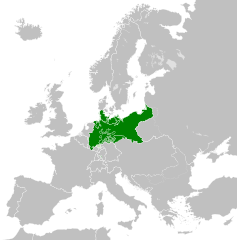
| ۳۱ مئی ۲۰۱۶، ساعت ۰۲:۴۰ |  | ۴۵۰ در ۴۵۶ (۶۶۲ کیلوبایت) | Alphathon | == {{int:filedesc}} == {{Inkscape}} {{Information |Description={{en|A map of the en:North German Confederation within Europe circa 1870 CE.}} |Source= {{Derived from|Blank_map_of_Europe.svg|display=50}} |Date=2016-05-31 |Author=*[[:File:Bla... |
فايل ایشلدمهسی
آشاغیداکی صحیفه بو فایلا باغلانیر
فایلین باشاباش ایشلنیلمهسی
بو فایل آشاغی داکی آیری ویکی لرده ایشلَنیر:
- ang.wikipedia.org-ده ایشلنمهسی
- ar.wikipedia.org-ده ایشلنمهسی
- bg.wikipedia.org-ده ایشلنمهسی
- cs.wikipedia.org-ده ایشلنمهسی
- en.wikipedia.org-ده ایشلنمهسی
- es.wikipedia.org-ده ایشلنمهسی
- eu.wikipedia.org-ده ایشلنمهسی
- fa.wikipedia.org-ده ایشلنمهسی
- fi.wikipedia.org-ده ایشلنمهسی
- fr.wikipedia.org-ده ایشلنمهسی
- he.wikipedia.org-ده ایشلنمهسی
- hr.wikipedia.org-ده ایشلنمهسی
- is.wikipedia.org-ده ایشلنمهسی
- it.wikipedia.org-ده ایشلنمهسی
- ko.wikipedia.org-ده ایشلنمهسی
- lt.wikipedia.org-ده ایشلنمهسی
- lv.wikipedia.org-ده ایشلنمهسی
- ms.wikipedia.org-ده ایشلنمهسی
- pl.wikipedia.org-ده ایشلنمهسی
- pt.wikipedia.org-ده ایشلنمهسی
- ru.wikipedia.org-ده ایشلنمهسی
- sv.wikipedia.org-ده ایشلنمهسی
- th.wikipedia.org-ده ایشلنمهسی
- tr.wikipedia.org-ده ایشلنمهسی
- vi.wikipedia.org-ده ایشلنمهسی
- zh.wikipedia.org-ده ایشلنمهسی