فایل:Rzeczpospolita Rozbiory 2.png

سیناق گؤستریشی اؤلچوسو: ۷۲۷ × ۵۹۹ پیکسل. آیری کیفیتلر: ۲۹۱ × ۲۴۰ پیکسل | ۵۸۲ × ۴۸۰ پیکسل | ۹۳۲ × ۷۶۸ پیکسل | ۱٬۲۴۲ × ۱٬۰۲۴ پیکسل | ۱٬۹۰۲ × ۱٬۵۶۸ پیکسل.
فایلین اصلی (۱٬۹۰۲ × ۱٬۵۶۸ پیکسل, فایل اؤلچوسو: ۲۹۶ کیلوبایت, MIME نوعو: image/png)
قیساسی

|
این historical map نگاره میبایست با استفاده از گرافیک برداری اسویجی فایل بازسازی شوند. این چند مزیت دارد؛ Commons:Media for cleanup را برای اطلاعات بیشتر ببینید. اگر حالت برداری آن در حال حاضر موجود است، لطفاً آن را بار کنید. پس از بارکردن یک اسویجی، این الگو را با {{vector version available|new image name.svg}} جایگزین کنید.
|
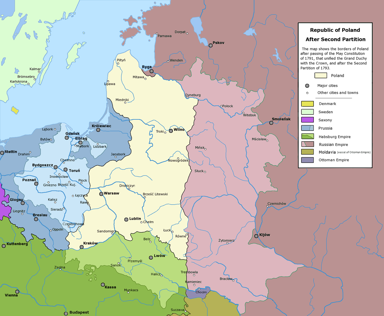
Poland after the Second Partition.
لیسانس
The following is a list of maps created by Halibutt and uploaded to commons, as well as their present and projected derivatives.
| Parent Image | Image | Description | |||||||||||
|---|---|---|---|---|---|---|---|---|---|---|---|---|---|
| Maps by Halibutt | |||||||||||||
| Image:Rzeczpospolita.png | Image:Rzeczpospolita.png | The Republic in 17th and 18th century | |||||||||||
| Image:Rzeczpospolita 1600.png | The Republic after the Treaty of Dywilino | ||||||||||||
| Image:Rzeczpospolita voivodships.png | Voivodships of The Republic | ||||||||||||
| Image:Rzeczpospolita_Potop.png | The Republic during The Deluge and Chmielnicki Uprising, with major battles of the era marked | ||||||||||||
| Magnates and their lands and domains | |||||||||||||
| 1st • 2nd • 3rd | Partitions of Poland | ||||||||||||
| War of the constitution | |||||||||||||
| Image:Rzeczpospolita.xcf | SOURCE FILE - GIMP format | ||||||||||||
| Image:Poland 1939.png | Image:Poland 1939.png | Poland in 1939 | |||||||||||
| Image:Dywizje wrzesien 1.png | Order of Battle on September 1st, during the Polish Defence War of 1939 | ||||||||||||
| Image:Poland 1939.xcf | SOURCE FILE - GIMP format | ||||||||||||
| Image:Polska kontur bialy.png | Image:Polska kontur bialy.png | Contour map of Poland AD 1999, for use with various locator maps | |||||||||||
| Image:Rzeczpospolita 1923.png | Image:Rzeczpospolita 1923.png | Map of Poland 1918-1939, currently under development | |||||||||||
| Image:PBW March 1919.png | Polish-Bolshevik War - fronts in March of 1919 | ||||||||||||
| Image:PBW December 1919.png | Polish-Bolshevik War - fronts in December of 1919 | ||||||||||||
| Image:PBW June 1920.png | Polish-Bolshevik War - fronts in July of 1920 | ||||||||||||
| Image:PBW August 1920.png | Polish-Bolshevik War - fronts in August of 1920 | ||||||||||||
| Polish Defence War of 1939 | |||||||||||||
| Polish areas annexed by Germany, Lithuania, Slovakia and the Soviet Union | |||||||||||||
| German concentration camps in Poland | |||||||||||||
| Curzon line | |||||||||||||
| Major battles of the Polish-Bolshevik War | |||||||||||||
| names • no names | Polish/Czechoslovak/Lithuanian/German/Ukrainian claims in 1920's | ||||||||||||
| Image:Rzeczpospolita Central Lithuania.png | Central Lithuania | ||||||||||||
| Image:Rzeczpospolita Lithuania claims.png | Central Lithuania as compared with other Lithuanian claims | ||||||||||||
| Image:Rzeczpospolita 1789-1920.png | Post-1922 borders compared with the territory of Poland before the partitions | ||||||||||||
| Warsaw Uprising and the Operation Tempest | |||||||||||||
| Poland partitioned between the Soviets and the Germans | |||||||||||||
| Image:Rzeczpospolita 1939 Polish divisions.png | Polish divisions on September 1, 1939 | ||||||||||||
| Home Army inspectorates | |||||||||||||
| Image:Rzeczpospolita 1922.xcf | SOURCE FILE - GIMP format | ||||||||||||
| Image:Rzeczpospolita 1937.svg | Vector version!!!! | layered version available on request | |||||||||||
Since the legal status of the above comment has been questioned, I hereby grant anyone the right to treat it as either a standard copyright notice, invariant section, legal statement, legal advice, friendly suggestion or a mere comment, depending on his or hers own choice. |
|

فايل گئچمیشی
فايلین اولکی وئرسیياسینی گؤرمک اۆچون گۆن/تاریخ بؤلمهسیندهکی تاریخلری تێقلايین.
| تاریخ/واخت | کیچیک عکس | اؤلچولر | ایشلدن | باخیش | |
|---|---|---|---|---|---|
| ایندیکی | ۶ ژانویه ۲۰۱۸، ساعت ۰۳:۵۵ | | ۱٬۹۰۲ در ۱٬۵۶۸ (۲۹۶ کیلوبایت) | Alphathon | General cleanup |
| ۱۸ جولای ۲۰۱۶، ساعت ۱۹:۲۸ |  | ۱٬۹۰۲ در ۱٬۵۶۸ (۳۳۲ کیلوبایت) | Poeticbent | further correction for vision impared | |
| ۱۸ جولای ۲۰۱۶، ساعت ۱۶:۲۰ |  | ۱٬۹۰۲ در ۱٬۵۶۸ (۳۳۱ کیلوبایت) | Poeticbent | adjust to match others | |
| ۱۸ جولای ۲۰۱۶، ساعت ۱۶:۱۴ |  | ۱٬۹۰۲ در ۱٬۵۶۸ (۳۳۱ کیلوبایت) | Poeticbent | per en:Talk:Partitions of Poland - accessibility for people with color vision impairment, dead space cropped | |
| ۶ مئی ۲۰۱۶، ساعت ۱۴:۴۳ |  | ۲٬۰۰۰ در ۱٬۵۶۸ (۲۱۳ کیلوبایت) | Julieta39 | Cosmetic changes according with the sources cited in the discussion page of this day. | |
| ۲۴ فوریه ۲۰۱۰، ساعت ۱۴:۴۴ |  | ۲٬۰۰۰ در ۱٬۵۶۸ (۱۹۵ کیلوبایت) | Dcoetzee | Remove watermark, pngcrush | |
| ۳۱ ژانویه ۲۰۰۹، ساعت ۰۱:۳۰ |  | ۲٬۰۰۰ در ۱٬۵۶۸ (۲۸۱ کیلوبایت) | Mareklug | corrected mistake: legend color for H. Empire was off color (not green but white) | |
| ۱۶ فوریه ۲۰۰۶، ساعت ۲۰:۵۳ |  | ۲٬۰۰۰ در ۱٬۵۶۸ (۲۸۱ کیلوبایت) | Tomekpe | Corrected mistakes: * Silesia at the time belonged to Prussia, whereas the map shows it belonging to Austria. * Sweden no longer had Estonia. * Denmark no longer had the island off the coast of Estonia. * The Ottoman Empire did not control Hungary and Mo | |
| ۲۵ دسامبر ۲۰۰۵، ساعت ۲۱:۳۱ |  | ۲٬۰۰۰ در ۱٬۵۶۸ (۲۸۴ کیلوبایت) | Tomekpe | Halibutt's graphic with changing polish-russian border (Krasny Horodok area). Also deleted white rectangle. | |
| ۱۰ ژانویه ۲۰۰۵، ساعت ۱۳:۴۱ |  | ۲٬۰۰۰ در ۱٬۵۶۸ (۲۸۶ کیلوبایت) | Halibutt | Poland after the 2nd Partition<br>{{User:Halibutt/maps}}<br>{{User:Halibutt/GFDL}}<br>Category:Maps of Poland<br>Category:Historical maps |
فايل ایشلدمهسی
آشاغیداکی صحیفه بو فایلا باغلانیر
فایلین باشاباش ایشلنیلمهسی
بو فایل آشاغی داکی آیری ویکی لرده ایشلَنیر:
- ar.wikipedia.org-ده ایشلنمهسی
- be-tarask.wikipedia.org-ده ایشلنمهسی
- be.wikipedia.org-ده ایشلنمهسی
- bg.wikipedia.org-ده ایشلنمهسی
- br.wikipedia.org-ده ایشلنمهسی
- ca.wikipedia.org-ده ایشلنمهسی
- cs.wikipedia.org-ده ایشلنمهسی
- de.wikipedia.org-ده ایشلنمهسی
- dsb.wikipedia.org-ده ایشلنمهسی
- el.wikipedia.org-ده ایشلنمهسی
- en.wikipedia.org-ده ایشلنمهسی
- es.wikipedia.org-ده ایشلنمهسی
- et.wikipedia.org-ده ایشلنمهسی
- fa.wikipedia.org-ده ایشلنمهسی
- fi.wikipedia.org-ده ایشلنمهسی
- fr.wikipedia.org-ده ایشلنمهسی
- gl.wikipedia.org-ده ایشلنمهسی
- hr.wikipedia.org-ده ایشلنمهسی
- hu.wikipedia.org-ده ایشلنمهسی
بو فایلینسراسری ایستفاده لرینه باخین.