فایلین اصلی(۳٬۰۵۱ × ۳٬۳۵۹ پیکسل, فایل اؤلچوسو: ۳۳۹ کیلوبایت, MIME نوعو: image/png)

بو فایل ویکی‌انبار-دن‌دیر و آیری پروژه‌ده ایستیفاده اولماق امکانی وار. اونون باره‌سینده اولان شرح فایلین شرح صحیفه‌سی آشاغیدا گوستریلیب.

قیساسی

آچیقلاما
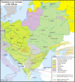
Русский: Карта расселения славян и их соседей на конец VIII века. Границы некоторых государств показаны начиная с VII в. Основана в восточнославянской части в основном на археологических картах и описаниях, в частности взятых из работ В.В.Седова (в основном данные по славянам) и тома "Финно-угры и балты в эпоху средневековья" (1987) из серии Археология СССР (в основном данные по балтам и финно-уграм). Подробности добавлены в 2023 г.: в то время Венеция все еще находилась в составе Византийской империи. Авары также присутствовали вокруг Вены и в центральной Трансильвании, о чем свидетельствуют могилы и топонимы. Между албанцами и влахами существовал языковой контакт, о чем свидетельствуют неславянские слова, присутствующие в обоих языках. Поместили Этелькез мадьяр и крымских византийских греков. Южнославянские топонимы (как Трнава означает «вершина, пригорок, насыпь») свидетельствовали о южнославянском присутствии в южной Трансильвании. Что касается носителей восточного романса (называемых влахами или волохами), выбор националистической позиции, как реверта 2022 года, редуктивен: здесь нет причин показывать только теорию «А» (Awarenwüste или «Пустыня Авары» в соответствии с Франц-Джозеф Сулцер, Йозеф-Карл Эдер, Йоханн-Кристиан Фон Энгель и Эдуард-Роберт Росслер в Romänische Studien: Untersuchungen Zur älteren Geschichte rumäniens, Лейпциг 1871: видеть Béla Köpeczi, Erdély rövid története, Akadémiai Kiadó ISBN 963 05 5901 3), в котором утверждается, что влахи жили только на юге Дуная в период поздней античности и Средневековья, и исключается теория «B», которая утверждает что волохи жили только на севере Дуная (видеть Румена Даскалова и Александра Везенкова «Запутанные истории Балкан - общее прошлое, спорное наследие», том III в «Библиотеке балкановедения», Brill 2015, ISBN  9004290362). Не зная о кочевом скотоводстве, которое, по общему мнению историков, этнологов и лингвистов, было до конца Средневековья основным занятием влахов, обе теории утверждали, что Дунай и Карпаты были до XIII в., открытые границы для славян и мадьяр, но непреодолимые преграды для влахов/волохов и только для них, причем отсутствие неоспоримых доказательств их присутствия стоит доказательства отсутствия. Это относится к северному левому берегу Дуная в теории «А» и к южному правому берегу Дуная в теории «В», но иллюзия, созданная таким образом во вторичных источниках, то, что влахи исчезли на тысячу лет, чтобы впоследствии чудесным образом появиться снова (видеть Георге И. Брэтиану, «Румыны, загадка и историческое чудо», выпуски Гражданской академии, Бухарест, 2019 г., ISBN 9786068924069), является абсурдном.
English: Map of the settlement of the Slavs and their neighbors at the end of the 8th century. The borders of some states are shown starting from the 7th century. It was founded in the East Slavic part mainly on archaeological maps and descriptions, in particular, taken from the works of V.V. mainly data on the Balts and Finno-Ugric peoples). Details added 2023: Venice was still in the Byzantine Empire at this time. Avars were also present around Vienna and in central Transylvania, evidenced by graves & toponyms. There was a linguistic contact between Albanians and Vlachs, evidenced by the non-Slavic words present in both languages. Placed the Etelköz of the Magyars and the Crimean byzantine Greeks. South-Slavic toponyms (as Trnava for "tip, hillock, mound") evidenced a South-Slavic presence in southern Transylvania. Concerning the Eastern romance speakers (called Vlachs or Volokhs), to choose a nationalist positioning, as the 2022 revert, is reductive: here is no reason to show only the theory A ("Awarenwüste" or "Desert of the Avars" of Franz-Josef Sulzer, Josef-Karl Eder, Johann-Christian von Engel and Eduard-Robert Rössler in Romänische Studien: untersuchungen zur älteren Geschichte Rumäniens, Leipzig 1871: see Béla Köpeczi's Erdély rövid története, Akadémiai Kiadó ISBN 963 05 5901 3) which affirms that the Vlachs lived only on the south of the Danube during Late antiquity and High Middle ages, and to exclude the theory B which affirms that the Volokhs lived only on the north of the Danube (see Rumen Daskalov and Aleksander Vezenkov's « Entangled Histories of the Balkans - Shared Pasts, Disputed Legacies » Vol. III in Balkan Studies Library, Brill 2015, ISBN 9004290362). Unaware the pastoral nomadism which, in the general opinion of historians, ethnologists and linguists, was until the end of the Middle Ages the main activity of the Vlachs, the both theories affirming that the Danube and the Carpathians were, before the 13-th century, open borders for the Slavs and the Magyars, but impassable obstacles for the Vlachs / Volokhs and only for them, the lack of indisputable proof of their presence being worth proof of absence. This applies to the northern left bank of the Danube in the theory A and to the southern right bank of the Danube in the theory B, but the illusion thus created in the secondary sources, that the Vlachs disappeared for a thousand years to miraculously reappear afterwards (see Gheorghe I. Brătianu, "The Romanians, an enigma and historical miracle" Academia Civică Publ., Bucharest 2019, ISBN 9786068924069) is a nonsense.
تاریخ
قایناق یوکله‌یه‌نین اؤز ایشی
یازار Koryakov Yuri

لیسانس

من، صاحب حقوق قانونی این اثر، به این وسیله این اثر را تحث اجازه‌نامهٔ ذیل منتشر می‌کنم:
w:azb:کریئیتیو کامنز
تخصیص بیرگه پایلاشیم
بو فایل کریتیو کامانز مجوز ایله Attribution-Share Alike 3.0 اویغونلاشمامیش یاییملانیب‌دیر.
سیزین ایجازه نیز وار دیر:
  • بؤلۆشمک – اثرین کپی، پایلاشماق و چاتدیرماسی اوچون
  • تلفیق ائت – اثرین توتوشدورماسی اوچون
آشاغی داکی شرایطله:
  • تخصیص – اثری مؤلف و یا لیسئنزییالی طرفین‌دن گؤستریلدیی کیمی ایستیناد ائتملیسینیز (آنجاق سنی دستکلدیینی و یا اثردن ایستیفاده ائتمیینیزی تکلیف ائتمملیسینیز).
  • بیرگه پایلاشیم – اگر بو اثرده دَییشدیرمه، چؤندرمه، یا دا کؤک‌دن دوزلتمه ائتسز، اله گلمیش اثری یالنیز بیر ائشیت یوخسا اوخشار بیر مجوزین آلتیندا یاییملایابیلرسینیز .
این ethnographic map نگاره می‌بایست با استفاده از گرافیک برداری اس‌وی‌جی فایل بازسازی شوند. این چند مزیت دارد؛ Commons:Media for cleanup را برای اطلاعات بیشتر ببینید. اگر حالت برداری آن در حال حاضر موجود است، لطفاً آن را بار کنید. پس از بارکردن یک اس‌وی‌جی، این الگو را با {{vector version available|new image name.svg}} جایگزین کنید.

عنوان

شرحی یک‌خطی از محتوای این فایل اضافه کنید
Map of the settlement of Slavs and their neighbors at the end of the VIII century

آیتم‌هایی که در این پرونده نمایش داده شده‌اند

توصیف‌ها فارسی

source of file انگلیسی

مارس 2008

فايل گئچمیشی

فايلین اول‌کی وئرسیياسینی گؤرمک اۆچون گۆن/تاریخ بؤلمه‌سینده‌کی تاریخلری تێقلايین.

تاریخ/واختکیچیک عکساؤلچولرایشلدنباخیش
ایندیکی‏۱۲ آقوست ۲۰۲۳، ساعت ۱۵:۱۳‏۱۲ آقوست ۲۰۲۳، ساعت ۱۵:۱۳ تاریخینده‌کی سۆروموندن کیچیک گؤرونتوسو۳٬۰۵۱ در ۳٬۳۵۹ (۳۳۹ کیلوبایت)Gyalu22Reverted to version as of 13:16, 23 October 2022 (UTC) Look at the atlas, don't do your own research
‏۱ ژوئن ۲۰۲۳، ساعت ۱۷:۴۳‏۱ ژوئن ۲۰۲۳، ساعت ۱۷:۴۳ تاریخینده‌کی سۆروموندن کیچیک گؤرونتوسو۳٬۰۵۱ در ۳٬۳۵۹ (۳۰۹ کیلوبایت)Shibbolet3579enice was still in the Byzantine Empire at this time. Avars were also present around Vienna and in central Transylvania, evidenced by graves & toponyms. There was a linguistic contact between Albanians and Vlachs, evidenced by the non-Slavic words present in both languages. Placed the Etelköz of the Magyars and the Crimean byzantine Greeks. South-Slavic toponyms (as Trnava for "tip, hillock, mound") evidenced a South-Slavic presence in southern Transylvania. Concerning the Eastern romance spe...
‏۲۳ اوْکتوبر ۲۰۲۲، ساعت ۱۳:۱۶‏۲۳ اوْکتوبر ۲۰۲۲، ساعت ۱۳:۱۶ تاریخینده‌کی سۆروموندن کیچیک گؤرونتوسو۳٬۰۵۱ در ۳٬۳۵۹ (۳۳۹ کیلوبایت)Gyalu22Reverted bad faith edit, restored to version as of 26 July 2011. The Westermanns Atlas is an irrelevant source for the previous map, as only the Southern Carpathians are shown as possibly inhabited by the Wallachians.
‏۲۸ آوریل ۲۰۱۴، ساعت ۱۵:۰۹‏۲۸ آوریل ۲۰۱۴، ساعت ۱۵:۰۹ تاریخینده‌کی سۆروموندن کیچیک گؤرونتوسو۳٬۰۵۱ در ۳٬۳۵۹ (۳۰۲ کیلوبایت)Spiridon Ion CepleanuBulgarian kingdom & east-romance vlachs according with the universitary atlases of history and the Grosser Atlas zur Weltgeschichte, dir. Hans-Erich Stier, Westermann, 1985, ISBN 3-14-10-0919-8, pp. 50, 55-57, 61 & 64.
‏۲۶ جولای ۲۰۱۱، ساعت ۱۸:۲۷‏۲۶ جولای ۲۰۱۱، ساعت ۱۸:۲۷ تاریخینده‌کی سۆروموندن کیچیک گؤرونتوسو۳٬۰۵۱ در ۳٬۳۵۹ (۳۳۹ کیلوبایت)Koryakov YuriThe map's resolution is drastically decreased. Undo
‏۲۶ جولای ۲۰۱۱، ساعت ۰۴:۵۳‏۲۶ جولای ۲۰۱۱، ساعت ۰۴:۵۳ تاریخینده‌کی سۆروموندن کیچیک گؤرونتوسو۵۴۴ در ۵۹۹ (۳۲۹ کیلوبایت)Spiridon Ion CepleanuOn the original version of this map, the eastern romance language-spoken populations ("Vlachs" or "Volokhs") are draw only in a little area around Sredets (today Sofia), according with only one of the POVs, called "Röslerian" (since Eduard Robert Rösler
‏۱۰ مارس ۲۰۰۸، ساعت ۱۳:۵۲‏۱۰ مارس ۲۰۰۸، ساعت ۱۳:۵۲ تاریخینده‌کی سۆروموندن کیچیک گؤرونتوسو۳٬۰۵۱ در ۳٬۳۵۹ (۳۳۹ کیلوبایت)Koryakov Yuri{{Information |Description= |Source= self-made |Date=March 2008 |Author= Koryakov Yuri |other_versions= }} == Licensing == {{self|cc-by-sa-3.0}} Category:Maps of the history of Russia in Russian [[Category:Maps

آشاغیداکی 2 صحیفه‌لر بو فایلا باغلانیرلار

فایلین باشاباش ایشلنیلمه‌سی

بو فایل آشاغی داکی آیری ویکی لرده ایشلَنیر:

بو فایلینسراسری ایستفاده لرینه باخین.

مِتابیلگی‌لر