فایل:Strait of Gibraltar perspective.jpg

سیناق گؤستریشی اؤلچوسو: ۸۰۰ × ۴۸۰ پیکسل. آیری کیفیتلر: ۳۲۰ × ۱۹۲ پیکسل | ۱٬۰۲۴ × ۶۱۵ پیکسل | ۱٬۵۲۸ × ۹۱۷ پیکسل.
فایلین اصلی (۱٬۵۲۸ × ۹۱۷ پیکسل, فایل اؤلچوسو: ۱۸۲ کیلوبایت, MIME نوعو: image/jpeg)
قیساسی
| آچیقلاما |
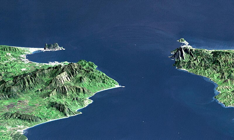
English: "This perspective view shows the Strait of Gibraltar, which is the entrance to the Mediterranean Sea from the Atlantic Ocean, with a 3-times vertical exaggeration to enhance topographic expression. Europe (Spain) is on the left. Africa (Morocco) is on the right. The Rock of Gibraltar, administered by Great Britain, is the peninsula in the back left." (quotation taken from the more detailed NASA description page)
Deutsch: Straße von Gibraltar; Aufnahme der NASA dreifach überhöht. Erstellt aus Daten von SRTM und Landsat
Français : Vue en perspective du détroit de Gibraltar ouvrant sur la mer Mediterranée avec le Maroc à droite et l'Espagne a gauche. coté espagnol on remarque le rocher de Gibraltar, en face le petit rocher est Ceuta, territoire espagnol en terre africaine.
Español: Peñón de Gibraltar |
| تاریخ |
|
| قایناق | http://photojournal.jpl.nasa.gov/catalog/PIA03397 |
| یازار | NASA / JPL / NIMA |
| آیری نوسخهلر |
Derivative works of this file: |
لیسانس
| این پرونده در مالکیت عمومی قرار دارد چرا که توسط ناسا ایجاد شده است. سیاست حق تکثیر ناسا بیان میکند که «مواد ناسا با حق تکثیر محافظت نمیشوند، مگراینکه ذکر شده باشد». (Template:PD-USGov، صفحهٔ سیاست حق تکثیر ناسا یا سیاست جیپیال استفاده از تصاویر را ببینید.) | ||
 |
هشدارها:
|
| Annotations | This image is annotated: View the annotations at Commons |
فايل گئچمیشی
فايلین اولکی وئرسیياسینی گؤرمک اۆچون گۆن/تاریخ بؤلمهسیندهکی تاریخلری تێقلايین.
| تاریخ/واخت | کیچیک عکس | اؤلچولر | ایشلدن | باخیش | |
|---|---|---|---|---|---|
| ایندیکی | ۱۴ نوْوامبر ۲۰۰۵، ساعت ۰۰:۲۰ | | ۱٬۵۲۸ در ۹۱۷ (۱۸۲ کیلوبایت) | Oxam Hartog | en : Perspective view from the Strait of Gibraltar, Marocco is on rigth, Spain on left with the Rock of Gibraltar ahead on left. On the other side the little rock is Ceuta Spain territory on african continent fr: Vue en perspective du detroit de Gibaltar |
فايل ایشلدمهسی
آشاغیداکی صحیفه بو فایلا باغلانیر
فایلین باشاباش ایشلنیلمهسی
بو فایل آشاغی داکی آیری ویکی لرده ایشلَنیر:
- af.wikipedia.org-ده ایشلنمهسی
- ar.wikipedia.org-ده ایشلنمهسی
- az.wikipedia.org-ده ایشلنمهسی
- be.wikipedia.org-ده ایشلنمهسی
- bo.wikipedia.org-ده ایشلنمهسی
- br.wikipedia.org-ده ایشلنمهسی
- bs.wikipedia.org-ده ایشلنمهسی
- ca.wikipedia.org-ده ایشلنمهسی
- ckb.wikipedia.org-ده ایشلنمهسی
- de.wikipedia.org-ده ایشلنمهسی
- de.wiktionary.org-ده ایشلنمهسی
- en.wikipedia.org-ده ایشلنمهسی
- en.wikivoyage.org-ده ایشلنمهسی
- es.wikipedia.org-ده ایشلنمهسی
- et.wikipedia.org-ده ایشلنمهسی
- frr.wikipedia.org-ده ایشلنمهسی
- fr.wikipedia.org-ده ایشلنمهسی
- ja.wikipedia.org-ده ایشلنمهسی
- ka.wikipedia.org-ده ایشلنمهسی
- kbd.wikipedia.org-ده ایشلنمهسی
- ky.wikipedia.org-ده ایشلنمهسی
- lt.wikipedia.org-ده ایشلنمهسی
- mt.wikipedia.org-ده ایشلنمهسی
- nl.wikipedia.org-ده ایشلنمهسی
- pl.wiktionary.org-ده ایشلنمهسی
- pt.wikipedia.org-ده ایشلنمهسی
- ro.wikipedia.org-ده ایشلنمهسی
- ru.wikipedia.org-ده ایشلنمهسی
- ru.wiktionary.org-ده ایشلنمهسی
- sl.wikipedia.org-ده ایشلنمهسی
- sw.wikipedia.org-ده ایشلنمهسی
- uk.wikipedia.org-ده ایشلنمهسی
- uz.wikipedia.org-ده ایشلنمهسی
بو فایلینسراسری ایستفاده لرینه باخین.