فایل:The Old Town Hall - geograph.org.uk - 1042854.jpg
The_Old_Town_Hall_-_geograph.org.uk_-_1042854.jpg (۶۴۰ × ۴۲۶ پیکسل, فایل اؤلچوسو: ۸۲ کیلوبایت, MIME نوعو: image/jpeg)
قیساسی
| آچیقلاما |
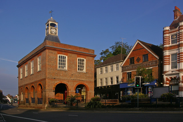
English: The Old Town Hall. This grade II* listed building (for listing particulars see http://www.heritagegateway.org.uk/Gateway/Results_Single.aspx?uid=289342&resourceID=5) was built in around 1728 as a replacement market hall for a similar building that once stood near West Street.
The cupola and clock were added in 1811 having been removed from the recently demolished nearby town prison ("the cage" - a new prison cage was built in what is now Cage Yard - see 1042857). In 1853, a chimney was added in each corner during alterations carried out by Lord Somers (who owned much of Reigate at the time) - they were removed in the 1980s, being out of keeping with the remainder of the building. It served as the town hall from 1863 to 1901, when the role transferred to the new municipal buildings in Castlefield Road (see 630757), after which it gained the name "Old Town Hall" by which it is now generally known. The building was used for petty court sessions from 1876, magistrates sitting there into the 1880s. It has been owned by the local council since 1922, with recent use including art and photographic exhibitions. However, following much debate over a longer term use to justify restoration, in 2008 it became a Caffe Nero coffee shop. Note the reference to a former user of the shop premises to the right of the building (now Carphone Warehouse) - Eames Outfitters; the building itself dates from the early 17th century and is grade II listed. |
| تاریخ | |
| قایناق | From geograph.org.uk |
| یازار | Ian Capper |
| موجَویز (required by the license) | Ian Capper / The Old Town Hall / |
| مختصات دوربین | | محل قرارگیری این نگاره و سایر نگارهها در: نقشهٔ شهری باز |
|---|
_heading:292.00&language=azb)
| مختصات شیء | | محل قرارگیری این نگاره و سایر نگارهها در: نقشهٔ شهری باز |
|---|
_heading:292.00&language=azb)
لیسانس

|
این نگاره از مجموعهٔ پروژهٔ Geograph گرفته شدهاست. این صفحهٔ عکسها را در وبگاه Geograph برای جزئیات تماس با عکاس ببینید. حق تکثیر این تصویر به Ian Capper تعلق دارد و برای استفادهٔ مجدد تحت Creative Commons Attribution-ShareAlike 2.0 مجوزدهی شدهاست.
|
- سیزین ایجازه نیز وار دیر:
- بؤلۆشمک – اثرین کپی، پایلاشماق و چاتدیرماسی اوچون
- تلفیق ائت – اثرین توتوشدورماسی اوچون
- آشاغی داکی شرایطله:
- تخصیص – اثری مؤلف و یا لیسئنزییالی طرفیندن گؤستریلدیی کیمی ایستیناد ائتملیسینیز (آنجاق سنی دستکلدیینی و یا اثردن ایستیفاده ائتمیینیزی تکلیف ائتمملیسینیز).
- بیرگه پایلاشیم – اگر بو اثرده دَییشدیرمه، چؤندرمه، یا دا کؤکدن دوزلتمه ائتسز، اله گلمیش اثری یالنیز بیر ائشیت یوخسا اوخشار بیر مجوزین آلتیندا یاییملایابیلرسینیز .
فايل گئچمیشی
فايلین اولکی وئرسیياسینی گؤرمک اۆچون گۆن/تاریخ بؤلمهسیندهکی تاریخلری تێقلايین.
| تاریخ/واخت | کیچیک عکس | اؤلچولر | ایشلدن | باخیش | |
|---|---|---|---|---|---|
| ایندیکی | ۲۳ فوریه ۲۰۱۱، ساعت ۲۲:۴۱ | | ۶۴۰ در ۴۲۶ (۸۲ کیلوبایت) | GeographBot | == {{int:filedesc}} == {{Information |description={{en|1=The Old Town Hall This grade II* listed building (for listing particulars see http://www.heritagegateway.org.uk/Gateway/Results_Single.aspx?uid=289342&resourceID=5) was built in around 1728 as a rep |
فايل ایشلدمهسی
آشاغیداکی صحیفه بو فایلا باغلانیر
فایلین باشاباش ایشلنیلمهسی
بو فایل آشاغی داکی آیری ویکی لرده ایشلَنیر:
- en.wikipedia.org-ده ایشلنمهسی
- en.wikivoyage.org-ده ایشلنمهسی
- fa.wikipedia.org-ده ایشلنمهسی
- lt.wikipedia.org-ده ایشلنمهسی
- nl.wikipedia.org-ده ایشلنمهسی
- pt.wikipedia.org-ده ایشلنمهسی
- ru.wikipedia.org-ده ایشلنمهسی
- zh.wikipedia.org-ده ایشلنمهسی