فایل:UNOSAT GazaStrip Damage Review 19Feb09 v3 Lowres.png
فایلین اصلی (۲٬۴۸۱ × ۳٬۵۰۹ پیکسل, فایل اؤلچوسو: ۴٫۵۴ مگابایت, MIME نوعو: image/png)
قیساسی
| آچیقلاما |
English: From UNOSAT site http://unosat.web.cern.ch/unosat/ Satellite-Based Gaza Strip Damage Assessment Overview
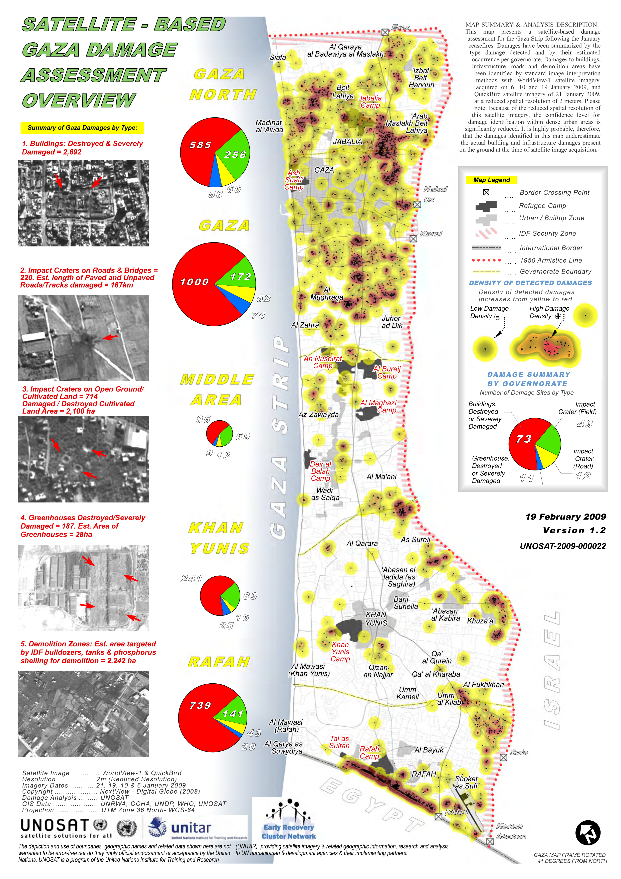
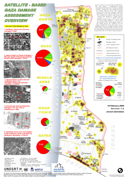
Product ID: 1338 - 10 Mar, 2009 - English This map presents a satellite-based damage assessment for the Gaza Strip following the January ceasefires. Damages have been summarized by the type damage detected and by their estimated occurrence per governorate. Damages to buildings, infrastructure, roads and demolition areas have been identified by standard image interpretation methods with WorldView-1 satellite imagery acquired on 6, 10 and 19 January 2009, and QuickBird satellite imagery of 21 January 2009, at a reduced spatial resolution of 2 meters. Please note: Because of the reduced spatial resolution of this satellite imagery, the confidence level for damage identification within dense urban areas is significantly reduced. It is highly probable, therefore, that the damages identified in this map underestimate the actual building and infrastructure damages present on the ground at the time of satellite image acquisition. Source(s): Satellite Image: WorldView-1 & QuickBird Resolution: 2m (Reduced Resolution) Imagery Dates: 21, 19, 10 & 6 January 2009 Copyright: NextView - Digital Globe (2008) Damage Analysis: UNOSAT GIS Data: UNRWA, OCHA, UNDP, WHO, UNOSAT Note: A test conversion from PDF to SVG using Inkscape produced errors. Arrows indicating bomb craters etc were handed as text but converted to F chars. |
| تاریخ | |
| قایناق | UNOSAT - United Nations |
| یازار | Sean.hoyland via PDF to PNG conversion |
| ایجازه (فایلین تکرار ایستیفادهسی) |
"produced or facilitated by UNOSAT for the humanitarian community from public sources. We ask you to kindly credit UNOSAT and/or the original source if this information is used in a report, project etc." |
لیسانس
| This image is a map derived from a United Nations map.
Unless stated otherwise, UN maps are to be considered in the public domain. This applies worldwide. UN maps are, in principle, open source material and you can use them in your work or for making your own map. UN requests however that you delete the UN name, logo and reference number upon any modification to the map. Content of your map will be your responsibility. You can state in your publication, if you wish, something like: based on UN map … (map name, map number, revision number and date). See: Geospatial Information Section. And: Geospatial, location data for a better world. |
 |

|
دارندهٔ حقتکثیر این پرونده به هر کسی اجازهٔ استفاده از آن را به هر منظوری میدهد، به شرط آنکه به شکلی مناسب به دارندهٔ حقتکثیر نسبت داده شود. توزیع مجدد، آثار مشتقشده، استفادهٔ تجاری، و تمام استفادههای دیگر مجاز است. |
|
|
فايل گئچمیشی
فايلین اولکی وئرسیياسینی گؤرمک اۆچون گۆن/تاریخ بؤلمهسیندهکی تاریخلری تێقلايین.
| تاریخ/واخت | کیچیک عکس | اؤلچولر | ایشلدن | باخیش | |
|---|---|---|---|---|---|
| ایندیکی | ۸ آوریل ۲۰۰۹، ساعت ۰۲:۱۰ | | ۲٬۴۸۱ در ۳٬۵۰۹ (۴٫۵۴ مگابایت) | Sean.hoyland | {{Information |Description={{en|1=Satellite-Based Gaza Strip Damage Assessment Overview Product ID: 1338 - 10 Mar, 2009 - English This map presents a satellite-based damage assessment for the Gaza Strip following the January ceasefires. Damages have been |
فايل ایشلدمهسی
آشاغیداکی صحیفه بو فایلا باغلانیر
فایلین باشاباش ایشلنیلمهسی
بو فایل آشاغی داکی آیری ویکی لرده ایشلَنیر:
- ar.wikipedia.org-ده ایشلنمهسی
- en.wikipedia.org-ده ایشلنمهسی
- fa.wikipedia.org-ده ایشلنمهسی
- he.wikipedia.org-ده ایشلنمهسی
- pt.wikipedia.org-ده ایشلنمهسی