فایل:Warwick 1834 OS map.png
یوخاری کیفیت الده یوخدور.
Warwick_1834_OS_map.png (۳۸۴ × ۳۸۴ پیکسل, فایل اؤلچوسو: ۲۸۴ کیلوبایت, MIME نوعو: image/png)
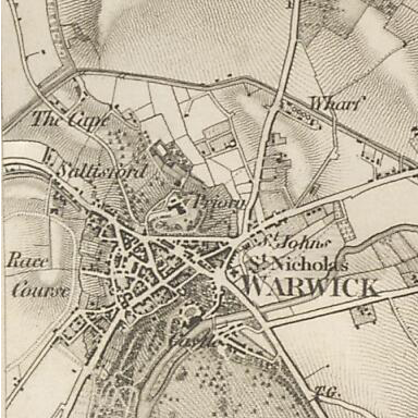
| آچیقلاما | OS map of Warwick in 1834. Scale 1:63360 (ie: one inch to one mile). |
| تاریخ | |
| قایناق | Ordnance Survey First Series, sheet 53. Published by the Ordnance Survey of Great Britain in 1834, hosted by Vision of Britain |
| یازار | Ordnance Survey of Great Britain |
This work is an Ordnance Survey map over 50 years old, which is covered by Crown Copyright which in this case expires 50 years after publication. Ordnance Survey does however ask that they be credited and that the date of publication be given.
Any ancillary rights gained through the creation of the electronic version are granted as freely usable under any circumstances.
|
This work created by the United Kingdom Government is in the public domain.
This is because it is one of the following:
HMSO has declared that the expiry of Crown Copyrights applies worldwide (ref: HMSO Email Reply)
|
 |
فايل گئچمیشی
فايلین اولکی وئرسیياسینی گؤرمک اۆچون گۆن/تاریخ بؤلمهسیندهکی تاریخلری تێقلايین.
| تاریخ/واخت | کیچیک عکس | اؤلچولر | ایشلدن | باخیش | |
|---|---|---|---|---|---|
| ایندیکی | ۲ دسامبر ۲۰۱۱، ساعت ۲۲:۲۳ | | ۳۸۴ در ۳۸۴ (۲۸۴ کیلوبایت) | Nev1 | {{Information |Description=OS map of Warwick in 1834. Scale 1:63360 (ie: one inch to one mile). |Source=Ordnance Survey First Series, sheet 53. Published by the Ordnance Survey of Great Britain in 1834, hosted by [http://www.visionofbritain.org.uk/maps/in |
فايل ایشلدمهسی
آشاغیداکی صحیفه بو فایلا باغلانیر
فایلین باشاباش ایشلنیلمهسی
بو فایل آشاغی داکی آیری ویکی لرده ایشلَنیر:
- de.wikipedia.org-ده ایشلنمهسی
- uk.wikipedia.org-ده ایشلنمهسی
- zh.wikipedia.org-ده ایشلنمهسی