واسک
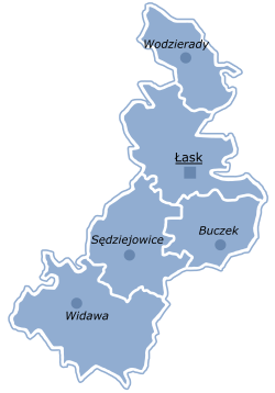
617.38 کیلومتر موربّع ساحهسی وار. واسک (لهیستانجا: Łask County) لهیستاندا بیر یاشاییش منطقهسیدیر و ووتسکی اوستانیندا یئرلشیر.
Łask County
Powiat łaski | |
|---|---|
 Location within the voivodeship | |
 Division into gminas | |
| موختصاتلار (Łask): 51°35′N 19°8′E / 51.583°N 19.133°Eموختصات: 51°35′N 19°8′E / 51.583°N 19.133°E | |
| اؤلکه | |
| Voivodeship | ووتسکی اوستانی |
| Seat | Łask |
| Gminas | |
| اراضی | |
| • Total | ۶۱۷٫۳۸ km2 (۲۳۸٫۳۷ sq mi) |
| جمعیت (2006) | |
| • Total | ۵۰٬۸۷۴ |
| • سیخلیق | ۸۲/km2 (۲۱۰/sq mi) |
| • شهر | ۱۸٬۶۸۴ |
| • Rural | ۳۲٬۱۹۰ |
| Car plates | ELA |
| وئب سایت | http://www.lask.com.pl |
Łask | |
|---|---|
 Collegiate Church of the Immaculate Conception of the Blessed Virgin Mary and Archangel Michael | |
| موختصاتلار: 51°35′N 19°8′E / 51.583°N 19.133°Eموختصات: 51°35′N 19°8′E / 51.583°N 19.133°E{{#coordinates:}}: نمیتوان بیش از یک برچسب اصلی در صفحه داشت | |
| اؤلکه | |
| Voivodeship | ووتسکی اوستانی |
| County | Łask County |
| Gmina | Gmina Łask |
| ایداره | |
| • Mayor | Gabriel Szkudlarek |
| اراضی | |
| • جمع | ۱۵٫۳۳ km2 (۵٫۹۲ sq mi) |
| جمعیت (31.12.2016) | |
| • جمع | ۱۷٬۶۰۴ |
| • سیخلیق | ۱٬۱۰۰/km2 (۳٬۰۰۰/sq mi) |
| ساعات قورشاغی | یوتیسی +1 (CET) |
| • یای (DST) | یوتیسی +2 (CEST) |
| Postal code | 98-100 |
| Car plates | ELA |
| وئب سایت | www |
بیرده باخ
دَییشدیرقایناقلار
دَییشدیراینگیلیسجه ویکیپدیاسینین ایشلدنلری طرفیندن یارانمیش«Łask»، مقالهسیندن گؤتورولوبدور.( ۱۲ ژوئن ۲۰۱۸ تاریخینده یوْخلانیلیبدیر).
| بو لهیستان ایله باغلی مقاله، بیر قارالاما مقاله دیر. بونو گئنیشلندیرمکله ویکیپدیایا کؤمک ائده بیلرسینیز. |


