فایل:Moon Farside LRO.jpg

فایلین اصلی (۱۸٬۰۰۰ × ۱۸٬۰۰۰ پیکسل, فایل اؤلچوسو: ۸۵٫۳۴ مگابایت, MIME نوعو: image/jpeg)
| هشدار | بعضی از مرورگرها با نمایش این تصویر با وضوح تصویر بالا مشکل دارند: این تصویر تعداد زیادی نقطه دارد و ممکن است به درستی در مرورگر شما بارگیری نشود یا باعث متوقف شدن مرورگر شما شود. |
|---|
Lower-resolution versions: 6000px, 3000px, and 1000px
قیساسی
| آچیقلاما |
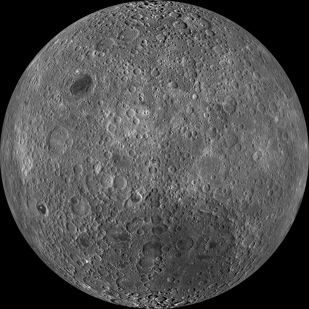
English: Far side of the moon, by NASA's Lunar Reconnaissance Orbiter. Orthographic projection centred at 180° longitude, 0° latitude.
Because the moon is tidally locked (meaning the same side always faces Earth), it was not until 1959 that the farside was first imaged by the Soviet Luna 3 spacecraft (hence the Russian names for prominent farside features, such as Mare Moscoviense). And what a surprise – unlike the widespread maria on the nearside, basaltic volcanism was restricted to a relatively few, smaller regions on the farside, and the battered highlands crust dominated. A different world from what we saw from Earth. Of course, the cause of the farside/nearside asymmetry is an interesting scientific question. Past studies have shown that the crust on the farside is thicker, likely making it more difficult for magmas to erupt on the surface, limiting the amount of farside mare basalts. Why is the farside crust thicker? That is still up for debate, and in fact several presentations at this week's Lunar and Planetary Science Conference attempt to answer this question. The Clementine mission obtained beautiful mosaics with the sun high in the sky (low phase angles), but did not have the opportunity to observe the farside at sun angles favorable for seeing surface topography. This WAC mosaic provides the most complete look at the morphology of the farside to date and will provide a valuable resource for the scientific community. And it's simply a spectacular sight! The Lunar Reconnaissance Orbiter Camera (LROC) Wide Angle Camera (WAC) is a push-frame camera that captures seven color bands (321, 360, 415, 566, 604, 643, and 689 nm) with a 57 km swath (105 km swath in monochrome mode) from a 50 km orbit. One of the primary objectives of LROC is to provide a global 100 m/px monochrome (643 nm) base map with incidence angles between 55° and 70° at the equator, lighting that is favorable for morphological interpretations. Each month, the WAC provides nearly complete coverage of the Moon under unique lighting. As an added bonus, the orbit-to-orbit image overlap provides stereo coverage. Reducing all these stereo images into a global topographic map is a big job, which is being led by LROC Team Members from the German Aerospace Center (Deutsches Zentrum für Luft- und Raumfahrt; DLR). Several preliminary WAC topographic products have appeared in LROC featured images over the past year (Orientale basin, Sinus Iridum). The WAC topographic dataset will be completed and released later this year. The global mosaic released today is comprised of over 15,000 WAC images acquired between November 2009 and February 2011. The non-polar images were map-projected onto the GLD100 shape model (WAC derived 100 m/px DTM), while polar images were map-projected on the LOLA shape model. In addition, the LOLA-derived crossover-corrected ephemeris and an improved camera pointing provide accurate positioning (better than 100 m) of each WAC image. |
| تاریخ | بین نوْوامبر ۲۰۰۹ و فوریه ۲۰۱۱ |
| قایناق | http://wms.lroc.asu.edu/lroc_browse/view/WAC_GL180 (see also http://photojournal.jpl.nasa.gov/catalog/PIA14021) |
| یازار | NASA/GSFC/Arizona State University |
| آیری نوسخهلر | Lower-resolution versions: 6000px, 3000px, and 1000px |
این نگاره یا ویدیو توسط آزمایشگاه نیروی محرکهٔ جت سازمان ملی هوانوردی و فضایی (NASA)ایالات متحدهٔ آمریکا تحت شناسهٔ عکس: PIA14021کاتالوگ شدهاست. این برچست وضعیت حق تکثیر اثر ضمیمه شده را مشخص نمیکند. یک برچسپ معمولی همچنان مورد نیاز است. Commons:Licensing را برای کسب اطلاعات مشاهده فرمایید. زبانهای دیگر:
|
لیسانس
| این پرونده در مالکیت عمومی قرار دارد چرا که توسط ناسا ایجاد شده است. سیاست حق تکثیر ناسا بیان میکند که «مواد ناسا با حق تکثیر محافظت نمیشوند، مگراینکه ذکر شده باشد». (Template:PD-USGov، صفحهٔ سیاست حق تکثیر ناسا یا سیاست جیپیال استفاده از تصاویر را ببینید.) | ||
 |
هشدارها:
|
| Annotations | This image is annotated: View the annotations at Commons |
فايل گئچمیشی
فايلین اولکی وئرسیياسینی گؤرمک اۆچون گۆن/تاریخ بؤلمهسیندهکی تاریخلری تێقلايین.
| تاریخ/واخت | کیچیک عکس | اؤلچولر | ایشلدن | باخیش | |
|---|---|---|---|---|---|
| ایندیکی | ۱۹ مارس ۲۰۱۴، ساعت ۲۳:۴۷ | | ۱۸٬۰۰۰ در ۱۸٬۰۰۰ (۸۵٫۳۴ مگابایت) | Huntster | High resolution mosaic. |
| ۹ آوریل ۲۰۱۱، ساعت ۰۴:۱۲ |  | ۱٬۶۰۰ در ۱٬۶۰۰ (۱٫۴۴ مگابایت) | Bubba73 | {{Information |Description ={{en|1=Far side of the Moon, by NASA's Lunar Recon. Orbiter}} |Source =http://apod.nasa.gov/apod/image/1104/farside_lro1600.jpg |Author =NASA - LRO |Date =2011? |Permission = |other_versions = } |
فايل ایشلدمهسی
بو فایلا هئچ بیر صفحهیه باغلانماییب.
فایلین باشاباش ایشلنیلمهسی
بو فایل آشاغی داکی آیری ویکی لرده ایشلَنیر:
- af.wikipedia.org-ده ایشلنمهسی
- az.wikipedia.org-ده ایشلنمهسی
- be.wikipedia.org-ده ایشلنمهسی
- bjn.wikipedia.org-ده ایشلنمهسی
- bn.wikipedia.org-ده ایشلنمهسی
- bs.wikipedia.org-ده ایشلنمهسی
- ca.wikipedia.org-ده ایشلنمهسی
- cs.wikipedia.org-ده ایشلنمهسی
- de.wikipedia.org-ده ایشلنمهسی
- en.wikipedia.org-ده ایشلنمهسی
- en.wikibooks.org-ده ایشلنمهسی
- en.wikiversity.org-ده ایشلنمهسی
- Solar System, technical/Moon
- User:Marshallsumter/Radiation astronomy2/Visuals
- Draft:Original research/Planets
- User:Marshallsumter/Radiation astronomy2/Visuals/Quiz
- User:Marshallsumter/Rocks/Rocky objects/Astronomy
- User:Marshallsumter/Radiation astronomy/Courses/Principles/Hourly 2
- User:Marshallsumter/Radiation astronomy/Courses/Principles/Midterm quiz
- User:Marshallsumter/Radiation astronomy/Courses/Principles/Final quiz
- Titan/Quiz
- User:Marshallsumter/Rocks/Rocky objects
- Draft:Enceladus/Quiz
- Moon/Quiz
- Stars/Sun/Heliology/Quiz
- Earth/Quiz
- Stars/Reds/Quiz
- Draft:Dione/Quiz
- User:Marshallsumter/Radiation astronomy2/Scattered disks/Quiz
- User:Marshallsumter/Radiation astronomy1/Kuiper belts/Quiz
- Liquids/Liquid objects/Moon
- User:Marshallsumter/Radiation astronomy/Craters
- es.wikipedia.org-ده ایشلنمهسی
- et.wikipedia.org-ده ایشلنمهسی
بو فایلینسراسری ایستفاده لرینه باخین.