آلبانی، نیویورک
آلبانی، نیویورک (اینگیلیسجه: Albany, New York) آمریکانین نیویورک ایالتیندا یئر آلان بیر شهردیر و ۵۶٫۸۱ کیلومتر موربّع ساحه سی وار. ۲۰۱۰-جی ایلين نۆفوس ساییمی اساسیندا ۹۷۸۵۶ نفر دیر. بۇ شهر متر دنیز سئوییهسیندن اۇجالیقیدا یئرلشیر.
Albany, New York | |
|---|---|
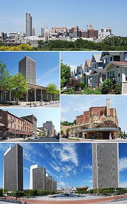
 Clockwise from top: Downtown from رنسلیر، نیویورک; middle-class housing in the Helderberg neighborhood; Palace Theatre; Empire State Plaza from the Cultural Education Center; North Pearl Street at Columbia Street; and the State Quad at آلبانیدهکی نیویورک ایالتی بیلیمیوردو. | |
| Etymology: Named for the Scottish Duke of Albany, whose title comes from the Gaelic name for ایسکاتلند: Alba | |
| لقب(لر): | |
| Motto(s): Assiduity[a] | |
 Boundaries of and major thoroughfares through Albany | |
 Location in Albany County and the state of نیویورک ایالتی | |
| موختصاتلار: 42°39′09″N 073°45′26″W / 42.65250°N 73.75722°Wموختصات: 42°39′09″N 073°45′26″W / 42.65250°N 73.75722°W | |
| Country | |
| State | |
| Region | Capital District |
| County | Albany |
| Settled | 1614 |
| Incorporation | 1686 |
| ایداره | |
| • نووع | Albany City Hall |
| • Mayor | Kathy Sheehan (آمریکا بیرلشمیش ایالتلرین دموکرات حزبی) |
| اراضی | |
| • State capital of نیویورک ایالتی | ۲۱٫۹۴ sq mi (۵۶٫۸۱ km2) |
| • توپراق | ۲۱٫۳۹ sq mi (۵۵٫۴۰ km2) |
| • سو | ۰٫۵۵ sq mi (۱٫۴۲ km2) |
| • متروپولیتن | ۶٬۵۷۰ sq mi (۱۷٬۰۰۰ km2) |
| لاپ اوجا یئری (On Birch Hill Road near Loudonville Reservoir) | ۳۷۸ ft (۱۱۵ m) |
| لاپ چوخور یئری (دنیز سویهسی (at the Hudson River)) | ۰ ft (۰ m) |
| جمعیت (2010) | |
| • State capital of نیویورک ایالتی | ۹۷٬۸۵۶ |
| • تخمین (2016) | ۹۸٬۱۱۱ |
| • سیخلیق | ۴٬۵۸۷٫۲۰/sq mi (۱٬۷۷۱٫۱۱/km2) |
| • متروپولیتن | ۱٬۱۷۰٬۴۸۳ |
| • متروپولیتن سیخلیغی | ۱۸۰/sq mi (۶۹/km2) |
| ساعات قورشاغی | یوتیسی −5 (EST) |
| • یای (DST) | یوتیسی −4 (EDT) |
| ZIP Code | 12201-12, 12214, 12220, 12222-32 |
| Area code | 518, 838 |
| ژئو کودو | 977310, 978659 |
| ایزو ۳۱۶۶ کودو | 36-01000 |
| FIPS code | 36-01000 |
| GNIS feature ID | 978659 |
| Demonym | Albanian |
| وئب سایت | www |
آلبانی شهرین نقشه اۆستونده یئری
گؤرونتولر
دَییشدیربیرده باخ
دَییشدیرائشیک باغلانتیلار
دَییشدیرقایناقلار
دَییشدیر- ^ MSN Encarta states that this nickname "resulted from the meeting here in 1754 of the Albany Congress, which adopted Benjamin Franklin's Plan of Union, the first formal proposal to unite the colonies."[۱] Archived 2009-10-29 at the Wayback Machine.. 2009-10-31.
- ^ شابلون:Vcite news
- ^ 2016 U.S. Gazetteer Files. United States Census Bureau. یوْخلانیلیبJul 4, 2017.
اینگیلیسجه ویکیپدیاسینین ایشلدنلری طرفیندن یارانمیش«Albany, New York»، مقالهسیندن گؤتورولوبدور. (۱۳ جولای ۲۰۱۷ تاریخینده یوْخلانیلیبدیر).
قایناق خطاسی برچسب <ref> برای گروهی به نام «lower-alpha» وجود دارد، اما برچسب متناظر با <references group="lower-alpha"/> یافت نشد.


