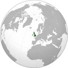
بؤیوک بریتانیا
بؤیوک بریتانیا بیر بویوک آدا دیر کی اطلس اوقیانوسو نون شومالیندا و اوروپا قارهسینین شومال غربینده یئرلشیب.
دوغما آدلار
| |
|---|---|
 | |
 | |
| جوغرافبا | |
| یئر | Northwestern Europe |
| موختصات | 53°50′N 2°25′W / 53.833°N 2.417°W |
| Archipelago | British Isles |
| Adjacent bodies of water | اطلس اوقیانوسو |
| اراضی | ۲۰۹٬۳۳۱ km2 (۸۰٬۸۲۳ sq mi)Convert internal error: unknown message[۱] |
| Area rank | 9th |
| Highest elevation | ۱٬۳۴۵ m (۴٬۴۱۳ ft) |
| Highest point | Ben Nevis[۲] |
| ایداری | |
بؤیوک بریتانیا | |
| Countries | اینگیلیس, ایسکاتلند, and ولز |
| Largest city | لندن (pop. 8,878,892) |
| اهلیتباخیشینان | |
| Population | 60,800,000 (2011 census)[۵] |
| Population rank | 3rd |
| Pop. density | ۳۰۲ /km۲ (۷۸۲ /sq mi) |
| دیللر | اینگیلیس دیلی, Scots, Welsh, Scottish Gaelic, Cornish |
| قومی قروپلار | |
| Additional information | |
| Time zone | |
| • Summer (DST) | |
قایناقلار
دَییشدیر- ^ ISLAND DIRECTORY Archived 2017-08-08 at the Wayback Machine., United Nations Environment Programme. Retrieved 9 August 2015.
- ^ "Great Britain’s tallest mountain is taller - Ordnance Survey Blog" (in en-GB). Ordnance Survey Blog. 2016-03-18. https://www.ordnancesurvey.co.uk/blog/2016/03/britains-tallest-mountain-is-taller/. بؤیوک بریتانیا
- ^ Ethnic Group by Age in England and Wales. www.nomisweb.co.uk. یوْخلانیلیب2 February 2014.
- ^ Ethnic groups, Scotland, 2001 and 2011. www.scotlandscensus.gov.uk. یوْخلانیلیب2 February 2014.
- ^ 2011 Census: Population Estimates for the United Kingdom. In the 2011 census, the population of England, Wales and Scotland was estimated to be approximately 61,370,000; comprising 60,800,000 on Great Britain, and 570,000 on other islands. Retrieved 23 January 2014