مانویل، نیوجرسی
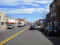
مانویل (اینگیلیسجه: Manville, New Jersey) آمریکانین نیوجرسی ایالتینده یئرلشن بیر شهر . بۇ یاشاییش یئرین اساسی ۱۹۲۹ -جو ایلده قۇیولموشدور. ۲۰۱۸-جی وئریلن معلوماتا اهالیسینین سایی ۱۰۲۳۴ نفر ایدی.
Manville, New Jersey | |
|---|---|
| Borough of Manville | |
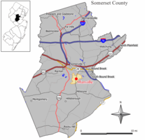
 Map of Manville in Somerset County. Inset: Location of Somerset County highlighted in the State of New Jersey. | |
 Census Bureau map of Manville, New Jersey | |
| موختصاتلار: 40°32′29″N 74°35′21″W / 40.54127°N 74.589273°Wموختصات: 40°32′29″N 74°35′21″W / 40.54127°N 74.589273°W[۱] | |
| Country | |
| State | |
| County | Somerset |
| Incorporated | April 18, 1929 |
| ایداره | |
| • نووع | Borough |
| • اورقانی | Borough Council |
| • Mayor | Richard Onderko (R, term ends December 31, 2023)[۲] |
| • Administrator | Brett Radi [۳] |
| • Municipal clerk | Wendy Barras[۴] |
| اراضی | |
| • جمع | ۲٫۴۴۹ sq mi (۶٫۳۴۲ km2) |
| • توپراق | ۲٫۳۶۱ sq mi (۶٫۱۱۴ km2) |
| • سو | ۰٫۰۸۸ sq mi (۰٫۲۲۸ km2) 3.60% |
| مساحت درجهسی | 376th of 566 in state 15th of 21 in county |
| اوجالیق | ۵۶ ft (۱۷ m) |
| جمعیت | |
| • جمع | ۱۰٬۳۴۴ |
| • تخمین (2018) | ۱۰٬۲۳۴ |
| • درجهسی | 237th of 566 in state 11th of 21 in county[۸] |
| • سیخلیق | ۴٬۳۸۲٫۰/sq mi (۱٬۶۹۱٫۹/km2) |
| • سیخلیق درجهسی | 134th of 566 in state 5th of 21 in county |
| ساعات قورشاغی | یوتیسی −5:00 (Eastern (EST)) |
| • یای (DST) | یوتیسی −4:00 (Eastern (EDT)) |
| ZIP Code | |
| تیلفون کودلاری | 908[۱۱] |
| FIPS code | 3403543620[۱۲][۱۳] |
| GNIS feature ID | 0885291[۱۴] |
| وئب سایت | رسمی وبسایت |
قایناقلار
دَییشدیر- ^ US Gazetteer files: 2010, 2000, and 1990, United States Census Bureau. Accessed September 4, 2014.
- ^ 2020 New Jersey Mayors Directory, New Jersey Department of Community Affairs. Accessed February 1, 2020.
- ^ [۱], Borough of Manville. Accessed November 12, 2019.
- ^ [۲], Borough of Manville. Accessed November 12, 2019.
- ^ 2010 Census Gazetteer Files: New Jersey County Subdivisions, United States Census Bureau. Accessed May 21, 2015.
- ^ U.S. Geological Survey Geographic Names Information System: Borough of Manville, Geographic Names Information System. Accessed March 7, 2013.
- ^ Profile of General Demographic Characteristics: 2010 for Manville borough[دائمی اولو باغلانتیلی], New Jersey Department of Labor and Workforce Development. Accessed February 13, 2013.
- ^ GCT-PH1 Population, Housing Units, Area, and Density: 2010 - State -- County Subdivision from the 2010 Census Summary File 1 for New Jersey[دائمی اولو باغلانتیلی], United States Census Bureau. Accessed February 13, 2013.
- ^ Look Up a ZIP Code for Manville, NJ, United States Postal Service. Accessed February 13, 2013.
- ^ Zip Codes, State of New Jersey. Accessed August 28, 2013.
- ^ Area Code Lookup - NPA NXX for Manville, NJ, Area-Codes.com. Accessed October 1, 2014.
- ^ American FactFinder Archived 2008-05-21 at the Wayback Machine., United States Census Bureau. Accessed September 4, 2014.
- ^ Geographic codes for New Jersey Archived 2019-06-04 at the Wayback Machine., Missouri Census Data Center. Accessed September 1, 2019.
- ^ US Board on Geographic Names, United States Geological Survey. Accessed September 4, 2014.
