استاینز
استاینز (اینگیلیسیجه: Staines-upon-Thames) بریتانیادا بیر یاشاییش منطقهسیدیر سوْن نۆفوس تخمینلرینه گؤره 18484 نفر دیر. بۇ شهر اینگیلیس اؤلکهسینده یئرلشیب.
- ^ [https://web.archive.org/web/20120424060625/http://list.english-heritage.org.uk/mapsearch.aspx Archived 2012-04-24 at the Wayback Machine. Ordnance Survey map, courtesy of English Heritage]
- ^ Key Statistics; Quick Statistics: Population Density Archived 2003-02-11 at the Wayback Machine. United Kingdom Census 2011 Office for National Statistics Retrieved 21 November 2013
- ^ New sectors and localities to 20 July 2012 (PDF). Royal Mail Address Management Unit (20 July 2012). آرشیولنیب اصلی نۆسخهدن on 2013-12-11. یوْخلانیلیب28 October 2012.
| Staines-upon-Thames | |
|---|---|
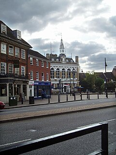
 Clarence Street and The Town Hall[n ۱] | |
| Area | ۷٫۸۶ km2 (۳٫۰۳ sq mi) |
| جمعیت | ۱۸٬۴۸۴ (2011 Census)[۲] |
| • Density | ۲٬۳۵۲/km2 (۶٬۰۹۰/sq mi) |
| OS grid reference | TQ045715 |
| Civil parish |
|
| District | |
| Shire county | |
| Region | |
| اؤلکه | England |
| موستقیل دوولت | United Kingdom |
| Post town | STAINES-UPON-THAMES[۳] |
| Postcode district | TW18 |
| تیلفون کودو | 01784 |
| UK Parliament | |
قایناق خطاسی برچسب <ref> برای گروهی به نام «n» وجود دارد، اما برچسب متناظر با <references group="n"/> یافت نشد.
