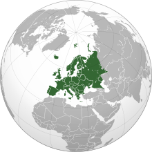
اوروپا
قاره
(اۇروپا-دن يوْللاندیریلمیش)
اوروپا، آفریقا قارّهسینین شومالیندا و آسیا قارّهسینین غربینده یئرلشن قارّه دیر. اوروپا، اطلس اوقیانوسونون غربینده و قوزئی یاریم کورهده یئرلشیر. یئنی ایقتیصادی و سیاسی بیرلشمه جریانی، بۇ قارّهنین بیر چوخ اؤلکهلرینی واحید دؤولت کیمی نیظاملاشدیریر.[۷]
 | |
| اراضی | ۱۰٬۱۸۰٬۰۰۰کیلومتر موربع (۶-جی)[a] |
|---|---|
| اهالی | 741,447,158 (2016; 3rd)[۱] |
| اهالی سیخیلیقی | 72.9/km2 (188/sq mi) (۲-جی) |
| جیدیپی (تخمینی) | ۲۱٫۸۲ تریلیون دولار (۲۰۱۸; ۳-جو)[۲] |
| جیدیپی (پیپیپی) | ۲۸٫۰۳ تریلیون دولار (۲۰۱۸; ۲-جی)[۳] |
| جیدیپی آدامباشی | ۲۹٫۴۵۰ دولار (۲۰۱۸; ۳-جو)[۴] |
| اچدیآی | |
| دئمونیمی | اوروپالی |
| اؤلکهلر | 50 sovereign states 6 with limited recognition |
| باغیملیلیکلر | 6 dependencies |
| دیللر | Most common first languages: |
| چاغ بؤلگهلری | یوتیسی ۱:۰۰- to یوتیسی ۵:۰۰+ |
| بویوک شهرلر | Largest urban areas: |
اوروپا قارّهسیندهکی اؤلکهلر
دَییشدیر- آلبانی
- آلمان
- آندورا
- اوتریش
- اوکراین
- ایرلند
- ایسپانیا
- ایسلند
- ارمنیستان
- ایسلوواکی
- ایسلوونی
- ایستونی
- آذربایجان جومهوریتی
- ایتالیا
- بلاروس
- بلژیک
- بولغاریستان
- بوسنی و هرزقووین
- بؤیوک بریتانیا
- پورتوقال
- تورکیه
- چک جومهوریسی
- دانمارک
- رومانی
- روسیه
- سان مارینو
- صربیستان
- سوئد
- سوئیس
- شومالی قیبریس تورک جومهوریتی
- فنلاند
- فرانسه
- قیبریس جومهوریتی
- قازاقیستان
- کروواسی
- کوزووو
- گورجیستان
- لیتوانی
- لتونی
- لهیستان
- لیختن ایشتاین
- لوکزامبورق
- ماجاریستان
- مقدونیه
- مالت
- مولداوی
- موناکو
- مونتنقرو
- نوروژ
- واتیکان
- هولند
- یونان
بیرده باخ
دَییشدیرقایناقلار
دَییشدیر- ^ World Population Prospects: The 2017 Revision. United Nations Department of Economic and Social Affairs, Population Division.
- ^ GDP Nominal, current prices. International Monetary Fund (2018). یوْخلانیلیب6 March 2018.
- ^ GDP PPP, current prices. International Monetary Fund (2018).
- ^ Nominal GDP per capita. International Monetary Fund (2018).
- ^ Reports – Human Development Reports.
- ^ The World's Cities in 2016. United Nations (2016).
- ^ Central Intelligence Agency - CIA - The World Factbook
خاریجی لینکلر
دَییشدیر- Council of Europe
- European Union
- The Columbia Gazetteer of the World Online Columbia University Press
- "Introducing Europe" from Lonely Planet Travel Guides and Information
Historical Maps